UPDATED 11:43
Lava has crossed Highway 137 at the 13-mile marker and has entered the ocean, according to Hawaii County Civil Defense.
A second flow is approximately 400 yards from Highway 137.
Highway 137 is closed between Kamaili Road and Pohoiki Road. Kamaili Road is closed between Highway 130 and Highway 137.
Residents in the area have been evacuated.
UPDATED 9:15 p.m.
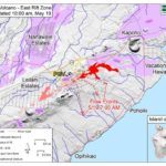
According to Hawaiian Volcano Observatory late Saturday, the flow originating from fissure 20 has again split into two lobes, both are currently heading in the general direction of the 13 mile marker on Highway 137.
Flow front No. 1 is approximately 630 yards from Highway 137 and moving about a 100 yards per hour. Flow front No. 2 is approximately 750 yards from Highway 137 and moving about the same speed. At the current rate, the lava flow may cross the highway within the next five to seven hours.
Highway 137 is closed between Kamaili Road and Pohoiki Road.
Kamaili Road is closed between Highway 130 and Highway 137 due to a brush fire. Residents in the area have been evacuated.
UPDATED 6:45 p.m.
Hawaii County Civil Defense says brush fires are threatening homes on Kamaili Road as a lava flow moves through the Malama Ki Forest Reserve. Residents need to evacuate immediately.
The lava was about a half mile from Highway 137 as of 6 p.m. Civil Defense said then it may cross within five to six hours.
UPDATED 6 p.m.
Hawaiian Volcano Observatory continues to monitor active lava flows in lower Puna, which have joined together into one flow, according to Hawaii County Civil Defense.
The flow currently is in state forest reserve lands and is heading in the general direction of MacKenzie State Park.
No structures were threatened as of 6 p.m.
The lava flow is about half a mile from Highway 137 and, at the current rate, may cross the highway within the next five to six hours, according to Civil Defense.
UPDATED 4:59 p.m.
Hawaii Electric Light Co. said today that it is developing plans to provide options for restoring electricity to communities in lower Puna that may be cut off by lava flows, the utility said in a news release this afternoon.
With lava moving more quickly over the past 48 hours, engineers were working near affected areas on Saturday to identify locations for portable generators and other equipment, the company said in the statement.
Plans include using traditional power systems, such as large-capacity diesel generators, as well as solar-battery-generator units. Options also include the use of steel poles that are able to span lava flows and temporarily connect to undamaged distribution lines.
HELCO also has created a page on its website for the latest information for customers affected by the eruption, and for those who may have questions about billing and service during the emergency. Visit https://www.hawaiielectriclight.com/lava.
UPDATED 2:45 p.m.
Hawaiian Volcano Observatory is monitoring active flows in state forest reserve lands that are heading in the general direction of MacKenzie State Park on the coast of lower Puna, according to Hawaii County Civil Defense.
The lava flow is currently 0.8 miles from Highway 137 and, at the current rate, might cross the highway within the next four to seven hours.
No residents are threatened at this time, but those living between Kamaili and Pohoiki are advised to decide if they want to voluntarily evacuate.
Three shelters remain open: The Pahoa Community Center, Keaau Community Center and Sure Foundation Church. The shelters are pet friendly.
EARLIER SATURDAY
Hawaii County Civil Defense said all residents are accounted for after a lava flow crossed Pohoiki Road on Friday and isolated about 40 homes.
“All of the three people who had been sheltering in place overnight have gotten out; two on their own, and one air-evacuated,” Janet Snyder, Hawaii County spokeswoman, said in an email. There were no injuries.
Another four people were evacuated by helicopter Friday evening.
Snyder said Bill Hansen of Civil Defense went door-to-door that morning getting names and numbers of residents on that road before the homes were isolated. “He was able to contact everybody late yesterday to ascertain that they all got out,” she said.
Civil Defense said Saturday morning that the flow remains active.
The agency described the flow as moving west of that road near Malama Ki Place. Four homes were destroyed but no highways are under threat at this time, according to Civil Defense.
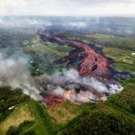
The flow, fed by fissure 20 near Lanipuna Gardens, has advanced 1,000 feet in under an hour.
The Hawaiian Volcano Observatory said the flow has three main lobes. Overall, eruption activity in lower Puna along Kilauea’s East Rift Zone remains high.
“This morning, the wide flow is very active and is advancing at rates up to 300 yards an hour,” HVO said in an update at 9:16 a.m. “A second flow from the same fissure complex is also flowing southward between Pohoiki and Opihikao roads.”
Meanwhile, a lava flow from fissure 18 continuous to advance more slowly, and fissure 17 is active, but its flow has slowed.
Fountaining is occurring at fissure 17 and fissures 16 to 20 have merged into a continuous line of spatter and fountaining, according to HVO.
Pohoiki Road is closed, and Highway 132 and 130 are open to local traffic.
A short-lived steam eruption at Kilauea’s summit occurred shortly before midnight. An ash plume reached 6,000 feet above sea level, and ash may be carried to the southwest.


