Lava almost completely fills Kapoho Bay, wipes out Champagne Ponds


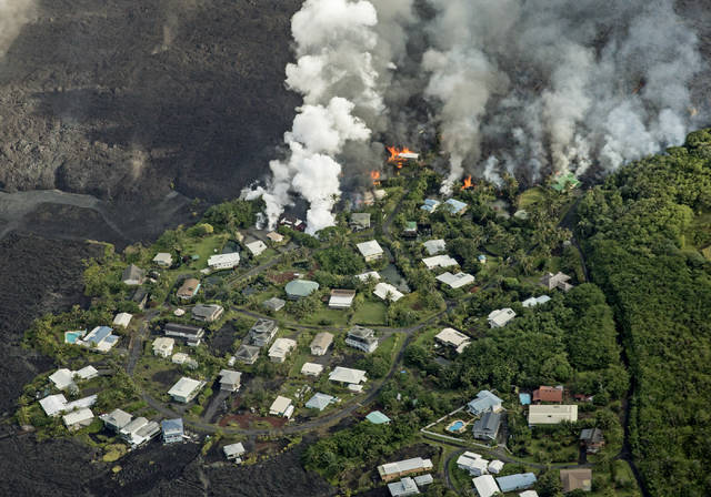
Lava consumed dozens of additional homes and a beloved island destination Monday after the flow filled in Kapoho Bay and destroyed Champagne Ponds.
Lava from Kilauea volcano consumed dozens of additional homes and a beloved island destination Monday as the flow filled in Kapoho Bay and destroyed Champagne Ponds.
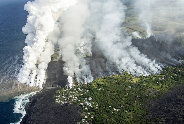
After the destructive fissure 8 flow entered the ocean at approximately 10:30 p.m. Sunday evening, the fast-moving lava rapidly produced a delta that began to fill in Kapoho Bay in lower Puna.
ADVERTISING
Jim Kauahikaua of the U.S. Geological Survey said the bay already was halfway filled in by noon Monday, and the flow reached the north side of the bay, where Champagne Ponds is located, by Monday evening.
Although the official number of homes destroyed by lava remained at 117 Monday, Hawaii County Civil Defense Administrator Talmadge Magno said he estimated an additional 42 Kapoho homes were destroyed throughout the day.
“And a lot of memories, too,” Magno said. “That’s a pretty precious part of the island for a lot of us.”
Vacationland evacuee Kymi Rutledge said late Monday afternoon the lava destroyed some of her neighbors’ homes and is “coming directly toward our (rental) house.”
“My husband’s lived here for 12 years, and I’ve lived here for four,” she said. “We came at different times, but we started a life together to build a life and live in paradise.”
The destruction of the previously picturesque Puna coast was disheartening for many, but Magno remained optimistic.
“I was talking to the mayor, and he was thinking that, ‘Yeah, it’s wiping out this part of the island as it is, but maybe there might be something more beautiful at the end of it,’” Magno said. “We try to make lemonade out of lemons.”
The lava flow already vaporized Green Lake in Kapoho Crater on Saturday, while the Kapoho tide pools appeared still intact late Monday evening.
Magno said the Keaau Armory shelter was full Monday, while the Pahoa shelter had about 300 additional openings.
Kauahikaua estimated several hundred cubic yards of lava were being produced per second, although he said such estimates are not exact.
The fissure 8 flow into Kapoho Bay cut off about 500 Kapoho homes from outside access Saturday. Magno said Monday that he had no official tally of residents remaining in the isolated area — although he said an earlier estimate of about a dozen seemed unrealistically low.
One additional resident was rescued by helicopter Monday; three other residents previously were rescued Sunday.
Magno said the county will conduct regular flyovers over the isolated area every day to see if residents are in any danger.
“We’re not going to run in there and drag them out,” Magno said.
Although the lava flow formed a channel from fissure 8 to the bay, other fingers of lava snaked north toward Cinder Road. One finger died out Monday, Kauahikaua said, while another looped around the Kapoho Cinder Cone, encircling it in lava.
Janet Babb, spokeswoman for the Hawaiian Volcano Observatory, said more than 20 square kilometers, or 5,000 acres, have been covered by lava since the eruption in the lower East Rift Zone began May 3.
The breadth of the fissure 8 flow — half a mile wide in some places — contributed to a high amount of lava haze, or “laze,” throughout Monday. Laze contains high amounts of hydrochloric acid, which can burn the skin of people exposed to it, as well as tiny fragments of volcanic glass. Therefore, residents are advised to avoid the area — Magno suggested a minimum distance of 1,000 feet away from the affected area, although winds can scatter the laze further.
Also dangerous is the amount of sulfur dioxide produced by the lower East Rift Zone fissures. Kauahikaua said the fissures are estimated to emit approximately 10,000 metric tons of sulfur dioxide each day.
National Weather Service meteorologist Leigh Eaton said the trade winds should remain steady for the next few days at least, blowing laze, vog and gas to the southwest.
At the summit of Kilauea, frequent earthquakes have begun to take their toll on structures in Hawaii Volcanoes National Park.
Parks spokeswoman Jessica Ferracane said the outdoor overlook at the Jaggar Museum displayed notable cracks after a 5.5 magnitude earthquake Sunday, although the adverse conditions within the park make it difficult to assess the damage.
Two other park buildings also sustained earthquake damage, and the entire park is without water service.
Work continues on potential evacuation routes out of lower Puna. Chain of Craters Road is ready for use as an emergency evacuation route, Magno said, although some additional gravel will be deposited on the road’s surface. However, Magno said the road will not open until an emergency, such as the closure of Highway 130, requires it.
Work began Monday on a second route that will loop from Highway 130 to Ala‘ili Road through Sanford’s Service Center Inc. north of Kamaili Road/Opihikao Drive. Delays are to be expected in that area.
Rutledge said since the eruption “we’ve lost our home, we’ve lost our cat. We have no family. … We came to start a life together, not to be homeless in Hawaii.”
Rutledge, who along with her husband was staying at the Keaau Armory shelter, also lamented the possible fate of the tide pools, now inaccessible and dangerously close to obliteration.
“It was the marine life that was there,” Rutledge said. “We’ve been out and swam with sea turtles, we swam with manta ray,we saw beautiful eels. Just things that aren’t going to be there any more. It’s a nice thing gone.”
Reporters John Burnett and Stephanie Salmons contributed to this story.
Email Michael Brestovansky at mbrestovansky@hawaiitribune-herald.com.


