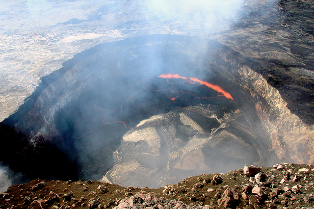
The recent high lava lake levels at Kilauea volcano have caught the attention of visitors and kama‘aina alike. But we shouldn’t forget that unrest at Mauna Loa continues.
Ongoing inflation in the upper Southwest Rift Zone and summit areas of Mauna Loa suggests that magma continues to rise into the volcano. The current rate and pattern of deformation are similar to the most recent episode of rapid inflation on Mauna Loa in 2004-2005. Earthquakes also have been occurring at elevated rates, particularly around the areas of inflation in the upper Southwest Rift Zone and summit.
Throughout its history, the USGS Hawaiian Volcano Observatory has taken advantage of advances in technology to better monitor volcanoes and earthquakes. Computers have become faster, methods of transmitting information have improved, and instrumentation has become smaller and more energy efficient. All these advances have been utilized to create an improved geophysical network that better supports HVO’s monitoring and science efforts.
In 2009, the American Recovery and Reinvestment Act enabled a major upgrade to HVO’s monitoring networks on Mauna Loa and Kilauea, including a conversion to digital telemetry, additional monitoring sites, and improved instrumentation. These enhanced networks can now detect earlier stages of unrest, and the resulting data enables more sophisticated analyses of volcanic processes than were previously possible.
Since the two most recent eruptions of Mauna Loa in 1975 and 1984, HVO started using GPS, broadband seismometers, and several types of analyses that were not possible with previous geophysical networks and computers. Certainly, these new data streams and analysis techniques have led to an improved understanding of Mauna Loa and its magma storage system.
Scientists often try to compare previous periods of unrest, such as those in 1975 and 1984, to current unrest to gain perspective on and understanding of what might happen next. With our improved ability to detect smaller and smaller earthquakes and deformation, it is important to keep in mind that signals being recorded now might not have been detectable in past years. This leads to some interesting questions that we’re trying to answer.
Were the small earthquakes that we can now record present during previous periods of unrest on Mauna Loa? If so, what was their pattern?
With entirely new techniques available, such as GPS and interferometric radar (InSAR), we can measure the deformation of wide areas on the volcano, which allows us to detect a large, inflating magma reservoir beneath Mauna Loa that previously could not have been detected. But, was this same reservoir active before previous eruptions?
Continuously recording GPS receivers measure episodes of hugely varying rates of inflation interspersed with times of no inflation, which might indicate fluctuations in magma supply to Mauna Loa’s shallow storage system. Did these fluctuations occur in the past? The comparison of current and past activity is not as trivial as one might think.
And finally, what will be the outcome of Mauna Loa’s current unrest? Scientists cannot be sure at this point.
Seismic unrest is currently much less energetic than it was before the 1975 and 1984 eruptions. Several episodes of increased inflation since 1984 slowed and stopped without eruption. Each of these episodes, however, resulted in greater pressurization of the shallow storage system within Mauna Loa. Unfortunately, we do not yet completely understand exactly how much pressure is involved, or how much internal pressure the overlying rock can bear before it breaks and allows magma to move toward the surface.
Our knowledge and characterization of volcanic systems constantly evolves as improved geophysical networks lead to new scientific discoveries. But before scientists can clearly distinguish between episodes of inflation and elevated earthquake activity that accompany only the intrusion of magma (with no eruption) and those that actually lead to an eruption, there is still much work to be done.
So, HVO scientists continue their diligent efforts to fully understand the processes at work beneath Mauna Loa and to monitor the volcano’s restless activity.
If any significant changes are observed, HVO will issue public notifications through media releases and our website updates (http://hvo.wr.usgs.gov/activity/maunaloastatus.php).
Kilauea
activity update
Kilauea’s summit lava lake dropped out of view early in the week in response to summit deflation. As of Thursday, the lake was about 37 m (120 ft) below the vent rim, or 29 m (95 ft) below the pre-overflow floor of Halema‘uma‘u Crater. Elevated seismicity and pronounced deformation beneath the south end of Kilauea’s summit caldera suggested an accumulation of magma in that area.
Kilauea’s East Rift Zone lava flow continues to feed widespread breakouts northeast of Pu‘u ‘O‘o. The most distant active lava was about 8 km (5 mi) from Pu‘u ‘O‘o when mapped on May 5.
Two earthquakes were reported felt on the Island of Hawai‘i in the past week.
On May 9, at 2:18 a.m. HST, a magnitude-4.5 earthquake occurred 8.8 km (5.5 mi) north of Na‘alehu at a depth of 8.8 km (5.5 mi). On May 10, at 7:21 a.m., HST, a magnitude-2.8 earthquake occurred 5.2 km (3.2 mi) southeast of Kilauea Summit at a depth of 1.9 km (1.2 mi).
Visit the HVO website (http://hvo.wr.usgs.gov) for past Volcano Watch articles, Kilauea daily eruption updates and other volcano status reports, current volcano photos, recent earthquakes, and more; call 967-8862 for a Kilauea summary update; email questions to askHVO@usgs.gov.
Volcano Watch (http://hvo.wr.usgs.gov/volcanowatch/) is a weekly article and activity update written by scientists at the U.S. Geological Survey’s Hawaiian Volcano Observatory.


