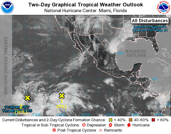
National Hurricane Center forecasters are monitoring an area of low pressure located just east of the Central North Pacific Basin.
National Hurricane Center forecasters are monitoring an area of low pressure located just east of the Central North Pacific Basin.
Forecasters say the weather system, located 2,000 miles southwest of the southern tip of Baja California and just east of the Central North Pacific Basin, has a 50 percent chance of developing into a tropical cyclone within five days. It has a 10 percent chance of formation during the next 48 hours.
Environmental conditions are expected to remain conducive for tropical cyclone development during the next several days as the low moves slowly toward the northwest, forecasters said.
The area of low pressure as of Thursday afternoon was located between 130 degrees west and 140 degrees west longitude, just within the Eastern Pacific Basin. The Central North Pacific Basin covers the area north of the equator spanning from 140 degrees west longitude to the International Date Line.
Should the storm be the first to form within the Eastern Pacific Basin, it will be named Andres. If it crosses into the Central North Pacific Basin before forming into a tropical cyclone it will be named Ela.
The center also is keeping tabs on a tropical wave located about 1,200 miles south-southwest of the southern tip of Baja California that is producing a large area of disorganized cloudiness and showers. The system changed little in organization between Wednesday and Thursday, and environmental conditions are currently not conducive for development. However, conditions are expected to become conducive for some slow development over the weekend.
Forecasters gave the weather system a 50 percent chance of forming into a tropical cyclone within five days and a 10 percent chance of developing within the coming 48 hours.
The Central Pacific hurricane season runs from June 1 to Nov. 30. The East Pacific hurricane season began May 15.


