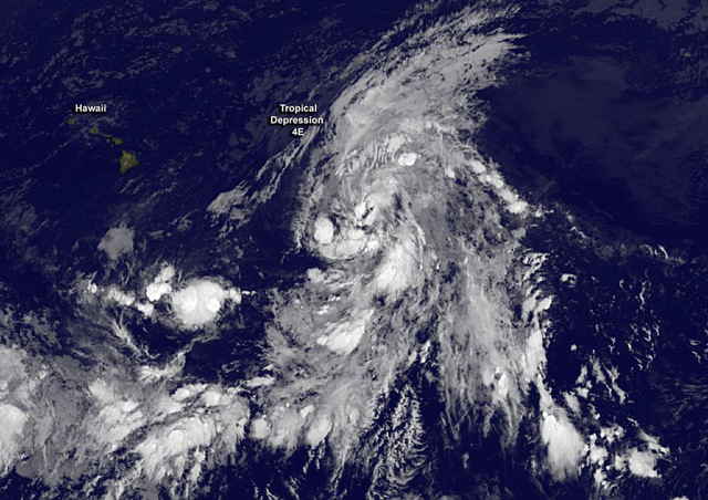
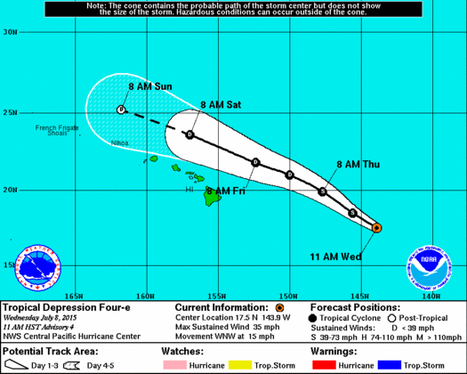
Tropical Depression 4E continues to trek northwest toward the Hawaiian Islands and could reach peak strength today as a tropical storm packing 40 mph winds. ADVERTISING Tropical Depression 4E continues to trek northwest toward the Hawaiian Islands and could reach
Tropical Depression 4E continues to trek northwest toward the Hawaiian Islands and could reach peak strength today as a tropical storm packing 40 mph winds.
While the system is forecast to pass well north of the island chain, multiple record-breaking weather factors in the Pacific have some experts predicting this could be the start of a busy few weeks.
The depression, 680 miles east of the Big Island, was packing maximum sustained winds of 35 mph Wednesday and moving toward the west-northwest about 16 mph, forecasters with the Central Pacific Hurricane Center said. Unseasonably warm waters in the 82- to 83-degree range are helping maintain the system, but increasing wind shear is expected to cap its strength and then weaken it back to a depression with 30 mph winds as it passes Friday and Saturday.
The passage of the system likely will disrupt the trade winds, leading to muggy and uncomfortable conditions, said Bob Burke, National Weather Service forecaster. Locally heavy showers are possible as the system drags tropical moisture along with it, and increased thunderstorms also could be on tap for leeward slopes.
The forecast initially called for the disturbance to be upgraded to a tropical storm by Wednesday, however, southwesterly shear in the area inhibited further organization. Air Force Reserve “hurricane hunters” made their first pass through the depression Wednesday morning, finding the center of the disturbance farther west than what meteorologists had thought, the squadron’s senior weather officer, Lt. Col. Jon Talbot, said. The data from the flight help forecasters more accurately determine the path of a storm.
“If you are off by 20 or 30 miles on where the center is, you can be a couple of hundred miles off, days out,” Talbot said.
Weaker systems lack a defined eye, making it harder for satellites to pinpoint their centers, Talbot said.
El Niño’s warmer waters stand to allow systems to track farther north toward Hawaii and maintain their strength longer this season, Talbot said.
If upgraded, 4E would be named Ela, and would be the first named storm of the 2015 Central North Pacific hurricane season. Hawaiian names are assigned only to storms that form in the Central North Pacific basin.
In other weather activity, showers and thunderstorms persist near a surface low about 600 miles south-southeast of Hilo. However, the system remains disorganized and forecasters said it is unlikely the system will develop into a tropical cyclone in the coming 48 hours.
West of the Big Island, showers and thunderstorms about 950 miles southwest of Honolulu could see some development during the next couple of days as the disturbance moves toward the northwest, forecasters said. It has a 60 percent chance of becoming a tropical depression within two days. Additionally, two other areas of low pressure off the coast of Mexico could develop into tropical cyclones in the next five days in the Eastern Pacific.
Several record-breaking factors are converging to crank up the Pacific hurricane season, several of them connected with El Niño, the cyclical warming of Pacific Ocean waters.
Eric Blake, a hurricane expert with the National Hurricane Center in Florida, said sea surface temperatures south and east of Hawaii broke records in June, hovering almost 2 degrees above normal.
Additionally, a very powerful westerly wind burst along the equator was on track for a July record, Blake tweeted Tuesday. These bursts, which reverse trade winds, help spawn cyclone systems.
Scientists with the NOAA Climate Prediction Center say El Niño is the largest it has been since 1997-98, a record year. Water temperatures along the equator hit 3 degrees above normal in the past week.
A record-warm Pacific is keyed up to start churning out cyclones during the next few weeks, Blake tweeted.
“It means the Eastern Pacific is about to get busy,” he said.
June packed a record-breaking punch in the Eastern Pacific as far as cyclone activity. NWS forecasters who measure the strength and duration of cyclones say June was at its highest level since reliable record-keeping began in 1971. Andres and Blanca were major hurricanes active in early June, followed by Hurricane Carlos, which was present June 10-17.
The level of Eastern Pacific activity was 3.5 times greater than normal.
Email Bret Yager at byager@westhawaiitoday.com.
Email Chelsea Jensen at cjensen@westhawaiitoday.com.


