Evidence of a mega-tsunami that slammed into Hawaii centuries ago is prompting Civil Defense agencies across the state to re-examine their evacuation zones. ADVERTISING Evidence of a mega-tsunami that slammed into Hawaii centuries ago is prompting Civil Defense agencies across
Evidence of a mega-tsunami that slammed into Hawaii centuries ago is prompting Civil Defense agencies across the state to re-examine their evacuation zones.
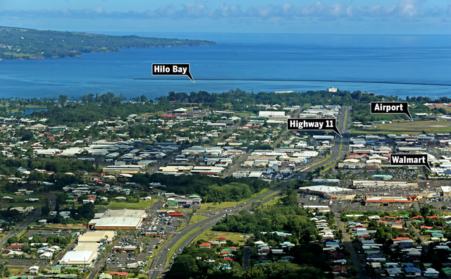
The rare monster wave could be powerful enough to reach Hilo’s Walmart — 2 miles from the shore — and put thousands of residents at risk, a leading researcher on the topic told the Tribune-Herald.
While existing tsunami warning signs aren’t expected to be changed, a separate and much larger evacuation area might be set aside for when the big one strikes.
Such “extreme evacuation zones” were unveiled Thursday for Oahu, and similar maps are expected to be finalized soon for the Neighbor Islands.
Kwock Fai Cheung, a University of Hawaii at Manoa ocean resources and engineering professor, created simulations for the disaster event, named the “Great Aleutian Tsunami.”
In addition to water reaching the “middle of Walmart,” he said his modeling shows a flooded Hilo International Airport and downtown Hilo under 10 meters (33 feet) of water.
“It’s like the worst-case scenario for Hawaii,” Cheung said.
But the likelihood of it happening anytime soon is very low.
Cheung said those estimates are based on a tsunami generated by a magnitude-9.3 or 9.6 earthquake hitting the eastern Aleutian islands, which probably happens about once every 1,000 years.
The event last happened at least 350 years ago, researchers believe.
But they’re not letting their guard down following the devastating tsunami that struck Japan in 2011.
Charles McCreery, Pacific Tsunami Warning Center director, said efforts to simulate and plan for a mega-tsunami began following the disaster. The location of the earthquake matters since the wave would have to hit Hawaii directly to cause that kind of damage.
“The main place that could affect us the worst would be that spot on the Aleutians,” he said.
Researchers know it happened before by studying sediment deposits in a sinkhole on Kauai.
The hole is located about 330 feet inland and 23 feet above sea level.
In a study published last October, researchers concluded that a 30-foot-tall tsunami deposited the sediment there between 1425 and 1665.
But the tsunami could be even larger in Hilo Bay.
In 1960, a 35-foot tsunami hit Hilo even though the rest of the state saw smaller waves. Sixty-one people died.
“Hilo Bay typically gets hit hard because of the shape of the bay,” said Barbara Muffler, curator of the Pacific Tsunami Museum. “It’s shallower, the waves are amplified and can reflect from one side or the other.”
McCreery said a tsunami generated by an Aleutian earthquake would take 4 to 4.5 hours to reach Hawaii.
A determination of its size could be made within half an hour to an hour, he said.
“That will give us at least three hours” to evacuate, McCreery said.
Hawaii County Civil Defense Administrator Darryl Oliveira said he expects to receive the final inundation maps for a Great Aleutian Tsunami soon.
That will determine where new warning signs will be posted and if any changes to evacuation maps need to be made, he said.
“There definitely will be changes to the Hilo community, and we will work with the community on those changes,” Oliveira said.
He said tsunami warning sirens also could be outfitted with a separate tone to distinguish between a mega-tsunami and other threats.
Oliveira said Hilo and Waipio Valley will see the biggest changes to evacuation areas.
“It’s for a very rare event, and we just need to be prepared for it,” he said.
Cheung said it’s unlikely that Kailua-Kona would see changes in its evacuation zones based on the simulations.
Email Tom Callis at tcallis@hawaiitribune-herald.com.


