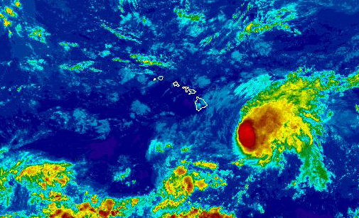
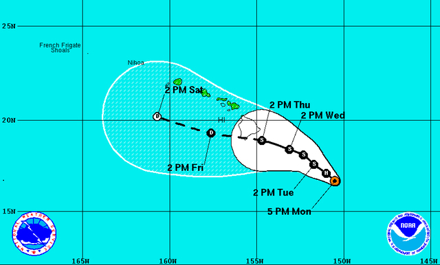
Strong vertical wind shear will continue to weaken Hurricane Hilda as the storm tracks toward the Big Island.
Strong vertical wind shear will continue to weaken Hurricane Hilda as the storm tracks toward the Big Island.
“We are expecting Hilda to weaken to a low-end tropical storm as it is just southeast of the Big Island Thursday,” said Central Pacific Hurricane Center meteorologist Chris Brenchley. “So, if it were to impact the Big Island it may be still a tropical storm or it could be a tropical depression.”
Hilda weakened to a Category 1 storm and was packing 90 mph winds as of Monday evening, according to the Central Pacific Hurricane Center in Honolulu. Located about 415 miles south-southeast of Kailua-Kona, the storm was traveling west-northwest at 6 mph.
Hurricane force winds extended outward up to 25 miles from the center of the storm while tropical storm force winds extend outward up to 90 miles.
Slow, but steady weakening is forecast during the coming 48 hours thanks to the wind shear, as well as dry mid-level air, forecasters said. Hilda is expected to be downgraded to a tropical storm Tuesday and a tropical depression by Friday.
Forecast models are providing differing tracks for the storm, the center said Monday. One model calls for Hilda to pass south of the Big Island while another has the storm moving north of the island before eventually heading toward Kauai by the end of the week.
“Each model has a little different interpretation of where wind shear will be strongest and where Hilda will interact with that. Some are saying it’s going to be stronger and go farther north, some say it will weaken fast and go south,” Brenchley said. “Models are still very diverging, and, so, probably what’s best to focus on is the larger cone that still encircles the entire state.”
A tropical storm watch could be issued today for the Big Island, Brenchley said. A tropical storm watch is issued when tropical storm conditions are possible within the specified coastal area within 48 hours.
Hawaii County Civil Defense Administrator Darryl Oliveira said the agency is continuing to monitor the storm and is working to ensure all partner agencies, as well as the public, stay informed. Updates are being posted online at www.hawaiicounty.gov/active-alerts and being broadcast on the radio, he said.
Though wind is a concern, Brenchley said Hilda’s main impact to the Big Island could be heavy rainfall.
“A lot of times, with a tropical storm or depression, the biggest impact is going to be the rain. A lot of times we get all the moisture of a hurricane but the winds are not quite as fast, so it sticks around quite a bit. Historically, the heaviest rain producers have been tropical storms and depressions,” he explained. “It’s still uncertain, but if we do see it ride through the islands, we do expect there’s going to be a threat for very heavy rain.”
The heaviest rain often falls where winds from a storm are heading upslope, Brenchley said. Should Hilda continue on its current forecast track, moving over the southern portion of the Big Island, the heaviest rain could be expected in East Hawaii. Should it track a little farther north, a west or south wind would result in rainfall along the Kona and Ka‘u slopes.
“Anywhere could get very heavy rain — we don’t want to say one spot in particular is more a threat than the other. At this point it is too early to tell,” he said.
With surf generated by Hilda already impacting Big Island shores, the National Weather Service issued a high surf advisory for east-facing shores that will remain posted until 6 a.m. Wednesday. The east-southwest swell was forecast to bring 6- to 10-foot waves by Monday that were forecast to increase to 8- to 12-foot waves by today.
Brenchley said wave heights of 6 to 8 feet were reported along the island’s east-facing shores Monday.
A hurricane warning also is in effect for Hawaiian offshore waters, including the portion of the Papahanaumokuakea Marine National Monument east of French Frigate Shoals. Seas of 12 feet or higher have been reported.
Hilda, the eighth named storm of the 2015 Eastern Pacific hurricane season, peaked as a Category 4 hurricane packing 140 mph winds Saturday before beginning its current weakening trend. It is the second storm to pass near the islands in less than a week following Guillermo, which approached the state as a hurricane before weakening to a tropical storm and ultimately passing north of the state.
“Don’t use Guillermo as a gauge for Hilda,” Brenchley cautioned.
Also being monitored Monday was disorganized showers and thunderstorms associated with an area of low pressure about 1,300 miles off the tip of the Baja California peninsula and an area of low pressure expected to form several hundred miles south of Mexico during the coming days. Forecasters said both weather systems have a low chance of forming into a tropical cyclone within the coming 48 hours.
Email Chelsea Jensen at cjensen@westhawaiitoday.com.


