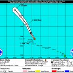
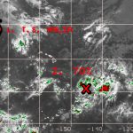
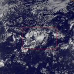
An area of showers and thunderstorms 900 miles southeast of the Big Island could form into a tropical cyclone by the end of the week.
“Most of the models are showing if it is to intensify, it is going to be very slow to do so,” said Bob Burke, a meteorologist with the National Weather Service in Honolulu. “It’s not looking like it will get going here in the short term. Models are showing it might take a little while and they are not showing anything getting real strong. Maybe in three or four days, it will be up to weak tropical storm.”
The weather system, which forecasters have been monitoring for the past several days, was showing signs of organization overnight Monday into early Tuesday as it tracked northwest, he said. However, signs of deterioration were evident Tuesday morning as it encountered 17 mph southwesterly shear. Wind shear often helps tear apart storms.
“If we were to start looking at something like this now, it’s not really classifiable as a tropical system because it’s weakened a little bit since last night,” he said.
Though the disturbance weakened Tuesday morning, Burke said little change was observed during the day. Models indicate the southwesterly shear will diminish during the next day or two as the system moves over 84-degree waters, which are conducive for tropical cyclone development.
“That might open up an opportunity for development,” he said.
Current forecast models and guidance have the weather system as a weak tropical storm packing 40 mph winds by the end of the week. Should it become a tropical storm, it would be named Niala. Within five days, it is expected to be several hundred miles east of the Big Island if it keeps on its current northwesterly track. Moisture from the weather system is at least a week to 10 days away from impacting the Big Island.
“We are working in tandem with NWS to keep a close watch on TD 96-C and are coordinating closely with local emergency management and civil defense agencies to ensure they are prepared for any potential impacts the storm may bring to our state,” said Vern Miyagi, administrator of the Hawaii Emergency Management Agency. “The public should monitor media channels for the latest updates on storm development over the next several days.”
Meanwhile, farther west in the Central Pacific, Tropical Storm Malia became post-tropical, which is a cyclone that no longer possesses sufficient characteristics to be considered a cyclone.
Malia was located 1,290 miles west-northwest of Kailua-Kona and moving north-northwest at 18 mph as of Tuesday afternoon, forecasters said.
Get more hurricane-related content, including preparation tips, evacuation info and daily tropical weather updates, on our hurricane season page, sponsored by Clark Realty, at www.westhawaiitoday.com/hurricane-season-2015.


