Big Island residents should now have a better idea where dengue cases are located. ADVERTISING Big Island residents should now have a better idea where dengue cases are located. Hawaii County Civil Defense has begun publishing on its website a
Big Island residents should now have a better idea where dengue cases are located.
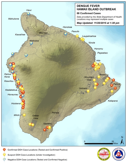
Hawaii County Civil Defense has begun publishing on its website a map of the island with pins showing where the confirmed and suspected cases are located.
While the information doesn’t provide street addresses, it gives a fairly detailed picture of how many cases are in an area and their general location. The map will be updated weekly, according to Civil Defense.
The information, along with a daily Civil Defense update on the outbreak, can be found at: www.hawaiicounty.gov/active-alerts/.
The map is part of a push by Civil Defense to provide greater information to the public in the fight against the disease, which, as of Friday, had sickened a total of 88 people, 75 of them residents and 13 visitors.
“This map should not be used to exclude any areas of the island from proactive mosquito control measures,” said Civil Defense Administrator Darryl Oliveira.
“All residents islandwide are encouraged to ‘Fight The Bite’ by reducing mosquito breeding grounds and protecting themselves from mosquito bites.”
On Saturday, workers were set to spray Konawaena middle and elementary schools, Kealakehe Intermediate, Honaunau and Hookena elementary schools, and Hilo and Waiakea high and intermediate schools. Konawaena High was set to be sprayed today. “There is no evidence to suggest the schools are a source of the outbreak; we’re treating the environment around them to lessen the likelihood of exposure and infection,” Oliveira said on Friday.


