The National Weather service has confirmed what you probably already knew, or at least suspected — 2015 was an unusually wet year on Hawaii Island. ADVERTISING The National Weather service has confirmed what you probably already knew, or at least
The National Weather service has confirmed what you probably already knew, or at least suspected — 2015 was an unusually wet year on Hawaii Island.
“Part of it is because of the wet summer. It really helped to boost the rainfall,” Kevin Kodama, a hydrologist for NWS, said Thursday. “The summer and fall would really stand out, because we had the wettest dry season in 30 years, especially on the Kona side, where you had record breaking rainfall during the late summer into early fall. That really pushed the numbers up in some areas, especially in South Kona along the coffee belt.”
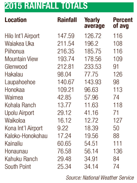
Honaunau, in the coffee belt, had an especially wet year for the leeward side of the island, with 76.58 inches of rainfall. That’s more than 20 inches more than its norm of 56.14 inches per year. Kainaliu, also in South Kona, received 60.65 inches of rain, 11 percent more than its usual yearly total of 54.51 inches.
Most rain gauges in East Hawaii, the windward side of the island and traditionally wetter than West Hawaii, also checked in with elevated precipitation totals in 2015.
Hilo International Airport recorded rainfall of 147.59 inches for the year, 16 percent above the average of 126.72 inches. The upland areas were even wetter, with Piihonua reporting 216.35 inches, 30-plus inches above normal. Waiakea Uka and Mountain View, with 211.54 inches and 193.74 inches, respectively, each received about 15 inches more than usual.
Some places received less rain than normal. One is Glenwood, an exceptionally wet spot in upper Puna, which recorded 212.81 inches, 20-plus inches below average.
The weather service is predicting a dry winter for the Big Island because of El Niño, a weather phenomenon associated with warm ocean surface temperatures in the Pacific.
“We’re definitely in it right now …,” Kodama said. “While we may see light bits of rain hit the Big Island here and there, overall, considering it’s in the wet time of year, the pattern looks very dry, overall. There’s not a whole lot of significant rain events on the horizon, at least for the next one to two weeks, so it’s following the playbook.”
Kodama said the Big Island should be dry into the spring, but was hesitant to predict beyond then.
“Beyond the next three to four months, I wouldn’t be able to say for sure,” he said. “It just depends on what this El Niño will do — and we really don’t know. But at least up to the spring, it’s going to be dry. So we’re probably going to start the year with rainfall deficits, and it could be pretty substantial. So it could take a pretty good rainfall to make up for that, considering we’re not likely to get very much rain in what should be a pretty wet time of year.”
Email John Burnett at jburnett@hawaiitribune-herald.com.
Record-setting heat for Hilo in 2015
Hilo saw its warmest year on record in 2015.
The average temperature was 76.2 degrees, which is 2.3 degrees above normal, according to the National Centers for Environmental Information. Forecasters attributed the hot year to El Niño, a weather phenomenon associated with warm ocean surface temperatures around the islands.
Temperature records for Hilo go back 66 years.


