Volcano Watch: A geologic tour of the Hawaiian Islands — Kauaʻi and Niʻihau

Welcome to the seventh annual Volcano Awareness Month on the Island of Hawaii.
ADVERTISING
Throughout January, the USGS Hawaiian Volcano Observatory, in cooperation with Hawaii Volcanoes National Park and the University of Hawaii at Hilo, will offer public talks around the island. For the complete schedule and details, visit HVO’s website (http://hvo.wr.usgs.gov).
As in years past, our January “Volcano Watch” articles will explore a theme associated with Hawaiian volcanism. The subject for this month’s series is the Hawaiian island chain itself. Each week, we will explore the volcanic history of an island or island group, beginning with Kauai and Niihau.
But first, let’s review the basic model for hot spot island formation — a model first proposed by Harold Stearns, a USGS geologist who mapped most of the Hawaiian Islands in the 1930s and ’40s.
Stearns recognized four stages to the growth of Hawaiian volcanoes:
1. Preshield (or submarine), when a volcano first starts to slowly grow underwater.
2. Shield, when eruptive activity is frequent and the volcano rapidly builds above sea level.
3. Postshield, when volcanic activity starts to wane and erosion outpaces resurfacing by lava.
4. Rejuvenated, when infrequent, isolated and small eruptions might occur up to millions of years after the postshield stage ends.
All Hawaiian volcanoes experience preshield and shield stages, but, for reasons that remain unclear, not all go through the postshield and rejuvenated stages.
The stages of Hawaiian volcanism are defined by the vigor of eruptive activity, as well as the chemical composition of the erupted lava, which changes with time as the volcano is rafted away from the hot spot. New data and insights continually refine this model, but the overall tenets remain largely unchanged since first proposed by Stearns more than 70 years ago.
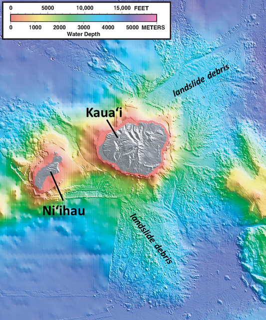
Unlike other Hawaiian islands, Kauai and Niihau are single volcanoes rather than amalgamations of overlapping volcanoes, and the two islands were never connected. Niihau probably formed first, since it is farthest west in the chain and volcanoes to the east are younger, but data indicating the exact onset times of the two volcanoes do not exist. We only know that both volcanoes formed about 6 million years ago.
Like all Hawaiian islands, Niihau and Kauai experienced periods of massive landslides throughout their histories, the evidence of which is preserved on the ocean floor as jumbles of rocky debris. Niihau once was much larger but the bulk of the island collapsed about 5 million years ago. The submarine collapse deposits were subsequently covered by lava during the growth of Kauai.
The geology of Kauai is complex. There is evidence for a huge caldera in the east-central part of the island, but it appears to mostly be a collapse feature that then was filled by lava. Geophysical data suggest the main center of volcanism was more or less beneath the Lihu‘e Basin, which subsided (by either collapse or faulting) between 3 and 4 million years ago.
The basin was subsequently filled by marine sediment and lava as it alternately subsided below sea level and then grew above sea level with lava inundation.
Vigorous shield-stage volcanism on Niihau and Kauai ended by about 4 million years ago, after which the islands’ spectacular canyons and cliffs began to form. Interestingly, rejuvenated volcanism has been long-lived on both islands. Elsewhere along the island chain, rejuvenated volcanism is minor. The gap between shield and rejuvenated eruptions on Niihau was about 2 million years, with the most recent eruption occurring about 350,000 years ago.
On Kauai, rejuvenated volcanism has occurred more or less continuously for the last 3.5 million years. The most recent eruption was only 150,000 years ago in the south part of the island, where black rock around the blowhole near Po‘ipu and cinder cones around Koloa look similar to young volcanic rocks on the Island of Hawaii. In fact, these eruptions are young enough to suggest rejuvenated volcanism on Kauai is not yet finished, but the odds of future eruptions in our lifetimes are small.
Next week, we explore the geological development of Oahu. Between now and then, Volcano Awareness Month talks are slated Monday (Jan. 11) at Hilo’s Lyman Museum and Tuesday (Jan. 12) in Hawaii Volcanoes National Park. Please join us.
Volcano activity updates
Kilauea continues to erupt at its summit and East Rift Zone.
During the past week, the summit lava lake level varied between about 28 and 35 m (95–115 ft) below the vent rim within Halema‘uma‘u Crater. On the East Rift Zone, scattered lava flow activity remained within about 6 km (4 mi) of Pu‘u ‘O‘o and is not currently threatening any nearby communities.
Mauna Loa is not erupting. Seismicity remains elevated above long term background levels. GPS measurements continue to show deformation related to inflation of magma reservoirs beneath the summit and upper Southwest Rift Zone of Mauna Loa.
Two earthquakes were reported felt on the Big Island this past week.
At 4:06 p.m. Dec. 31, a magnitude-2.6 earthquake occurred 4.7 km (2.9 mi) southwest of Keaau at a depth of 16.4 km (10.2 mi). At 9:38 a.m. Jan. 1, a magnitude-2.8 earthquake occurred 16.2 km (10.1 mi) southeast of Waimea at a depth of 15.5 km (9.6 mi).
Visit the HVO website (http://hvo.wr.usgs.gov) for past Volcano Watch articles, Kilauea daily eruption updates, Mauna Loa weekly updates, volcano photos, recent earthquakes info, and more; call for summary updates at 808-967-8862 (Kilauea) or 808-967-8866 (Mauna Loa); email questions to askHVO@usgs.gov.
Volcano Watch (http://hvo.wr.usgs.gov/volcanowatch/) is a weekly article and activity update written by scientists at the U.S. Geological Survey`s Hawaiian Volcano Observatory.


