Volcano Watch: Prodigious plumes present provocative puzzle
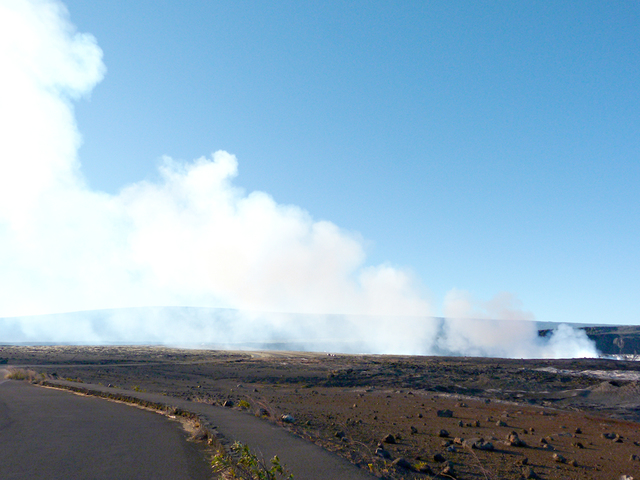
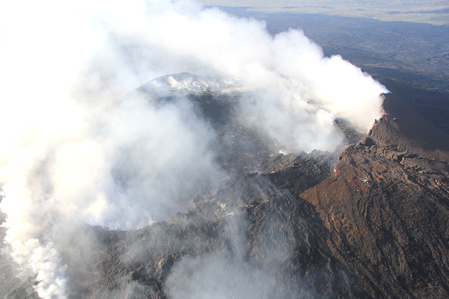
In recent weeks, the USGS Hawaiian Volcano Observatory has received a number of calls from local residents saying essentially: “Hey, is something up with Kilauea’s eruptions? The plumes at Halema‘uma‘u and Pu‘u ‘O‘o seem to be enormous lately.”
ADVERTISING
The short answer to this query is no. The summit and rift eruptions are going along steadily, as they have been for many months.
But the story behind this answer is a little more involved and worthy of further discussion.
People living in East Hawaii tend to stay respectfully aware of what’s going on with Kilauea and its attendant hazards. The year 2016 marks the 33rd anniversary of the volcano’s Pu‘u ‘O‘o eruption, with the past 30 years characterized by essentially continuous lava and gas discharge from East Rift Zone vents, and the eighth anniversary of Kilauea’s summit eruption within Halema‘uma‘u Crater. Through the many twists and turns of these years, the volcano’s beautiful lava fountains and flows have captivated the imaginations of residents and visitors alike.
These ongoing eruptions also continue to pose hazards. Lava flows destroyed homes, at times covering whole communities, and buried roads and other infrastructure. Polluting gases, with emission rates more than 10 times higher than the dirtiest coal-fired power plant on the U.S. mainland, sometimes impact the entire state.
Kilauea’s resident observers vary in their attentions to the volcano. Some simply cast a glance toward summit and rift zone eruption sites to observe the plumes while making their way to Hilo and back. Full-on eruption followers, on the other hand, stay semi-permanently tethered to HVO’s website, monitoring near real-time views of the summit lava lake along with surface deformation, gas output measures and earthquake displays.
Seasoned fume and plume watchers know the appearance and extent of Kilauea’s plumes are a function of several things, including the amount of gas coming out of the vents, the direction and speed of the wind and the temperature and relative humidity of the air around the volcano.
More gas discharge generally means a plume that looks bigger, but lower air temperature or higher relative humidity, which sometimes causes water vapor in an otherwise invisible plume to condense and become visible, can produce a similar result. The brisk wind speeds of Hawaii’s prevailing trade winds typically press the plumes close to the ground and carry gas and particle emissions to sparsely populated areas southwest of Kilauea’s vents.
The situation in recent months, especially the past few weeks, has been one in which Kilauea’s emissions have been fairly steady. We know this because HVO routinely operates instruments that precisely measure gas discharge.
These sensitive instruments show the volcano’s summit is releasing between 2,000 to 7,000 metric tons of sulfur dioxide (SO2) gas each day. The East Rift Zone has steadily emitted a much smaller amount, closer to 300 metric tons per day.
But atmospheric conditions during these same months have conspired to make Kilauea’s summit and rift emissions disconcertingly more evident to plume watchers.
First, since November, Hawaii’s winter (ho‘oilo) has brought a seasonally characteristic disruption to the trade winds. Slow-moving southerly (Kona) winds have taken their place, bringing Kilauea’s emissions into nearby East Hawaii communities, from Volcano to Hilo and beyond.
Second, but equally important, is the coincidence of the strongest El Nino in nearly 20 years. Typically, El Nino conditions in Hawaii produce wind direction reversals, compounding the seasonal trend already in play.
These wind reversals sustain very dry conditions, such as those we’re currently experiencing in East Hawaii.
According to the latest forecasts, we can expect this year’s El Nino to hang on until early summer (kau wela).
If this prediction comes true, it’s likely tall, vertically rising eruption plumes will adorn the skies above our steadily active volcano, giving Kilauea’s dedicated observers plenty to watch.
Volcano activity updates
Kilauea continues to erupt at its summit and East Rift Zone. During the past week, the summit lava lake level varied between about 31 and 38 m (102–125 ft) below the vent rim within Halema‘uma‘u Crater. On the East Rift Zone, scattered lava flow activity remains within about 6 km (4 mi) of Pu‘u ‘O‘o and is not currently threatening nearby communities.
Mauna Loa is not erupting. Seismicity remains elevated above long-term background levels. In the last week, earthquakes at Mauna Loa occurred mostly beneath the volcano’s upper Southwest Rift Zone and southern caldera region at depths of less than 5 km (3 mi). GPS measurements show continued deformation related to inflation of a magma reservoir beneath the summit and upper Southwest Rift Zone of Mauna Loa, with inflation recently occurring mainly in the southwestern part of the magma storage complex.
A magnitude-4.1 earthquake located beneath Kilauea’s south flank was recorded at 9:23 a.m. Friday (Feb. 12). The earthquake, which was widely felt on the Big Island, was located about 7.7 km (4.8 mi) west of Kalapana and 7.5 km (4.7 mi) southeast of the Pu‘u ‘O‘o crater, at a depth of 8.3 km (5.1 mi).
Visit the HVO website (http://hvo.wr.usgs.gov) for past Volcano Watch articles, Kilauea daily eruption updates, Mauna Loa weekly updates, volcano photos, recent earthquakes info, and more; call for summary updates at 808-967-8862 (Kilauea) or 808-967-8866 (Mauna Loa); email questions to askHVO@usgs.gov.
Volcano Watch (http://hvo.wr.usgs.gov/volcanowatch/) is a weekly article and activity update written by scientists at the U.S. Geological Survey`s Hawaiian Volcano Observatory.


