Hawaii County officials are making plans for a lava viewing area in Kalapana should the latest flow from Kilauea’s Pu‘u ‘O‘o vent advance over the top of Pulama pali.
Hawaii County officials are making plans for a lava viewing area in Kalapana should the latest flow from Kilauea’s Pu‘u ‘O‘o vent advance over the top of Pulama pali.
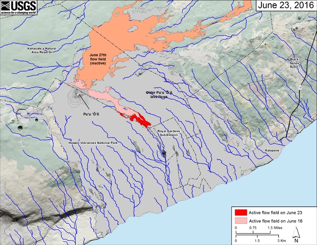
As of Thursday, the month-old flow was nearing the mauka boundary of the abandoned Royal Gardens subdivision but remained out of sight from the coastline.
Ed Teixeira, interim Civil Defense administrator, said parking stalls already have been marked at the former lava viewing area at the end of Highway 130. Additionally, plans are being made to allow people to walk down the gravel emergency route established in 2014 as the June 27 flow threatened to sever the highway in Pahoa.
That follows an 8-mile section of the former highway that previously was covered by lava.
As long as it remains safe, Teixeira said lava viewers would be allowed to hike down the 3-mile section that belongs to the county, which would take them near the makai boundary of the subdivision, also covered by earlier flows from Pu‘u ‘O‘o’s 33-year eruption. The rest is in Hawaii Volcanoes National Park.
“It is still considered an emergency route,” Teixeira said, regarding the decision to keep out vehicle traffic. “We want to protect the integrity of that.”
Asked about the possibility of lava covering the emergency route, he said, “If lava reaches it, lava reaches it. There’s nothing we can do.”
Security would be provided at the viewing area and volunteers might be used to help direct traffic and provide information about what to bring on the hike, he said. Similar protocols were followed when earlier flows from Pu‘u ‘O‘o were visible from Kalapana, a community previously inundated with lava.
“We’re following all kinds of procedures used in the past,” Teixeira said.
He said the park would remain the best place to view lava.
Hawaiian Volcano Observatory said the flow was about 330 feet from the former subdivision as of a Thursday overflight.
Geologists estimated it was also advancing at 330 feet per day, meaning the boundary could already have been reached. The flow itself is about 3.2 miles long with a developed tube system.
There are no homes left in the subdivision, so no property is at risk. But its boundary could be used as an indicator for how close the flow is to reaching the top of the pali and steeper terrain that could put it in view from Kalapana and the park.
HVO geologist Tim Orr said Friday the flow was probably “days” away from spilling down the hillside. He noted it’s difficult to define the top of the pali without being on the ground.
“The top rolls gently,” Orr said. “There isn’t a real strict boundary at the top.”
He estimated the flow was about a kilometer (about 0.62 of a mile) away from being visible, primarily at night, from the distant viewpoints.
“I think it has quite a ways to go before coming into view,” Orr said.
Once it does, or if it does, the additional influx of visitors hoping to catch a glimpse of lava could be good news for Puna businesses, less than two years after being at risk of isolation because of the now extinct June 27 flow.
“When it starts to come, all the tour buses will come,” said Leslie Lai, manager of Kaleo’s Bar &Grill in Pahoa.
“All the fishing boats will go into the water and become tour boats.”
Geologists say it’s hard to predict if lava will reach the coastline or when. The last time lava reached the ocean in that area was August 2013.
Orr said the flow likely will slow and fan out once it reaches the coastal plain. Breakouts upslope also could divert the flow or slow its advance.
Email Tom Callis at tcallis@hawaiitribune-herald.com.


