The National Weather Service is tracking the second Pacific hurricane and third named tropical cyclone of the season, less than six weeks into hurricane season. ADVERTISING The National Weather Service is tracking the second Pacific hurricane and third named tropical
The National Weather Service is tracking the second Pacific hurricane and third named tropical cyclone of the season, less than six weeks into hurricane season.
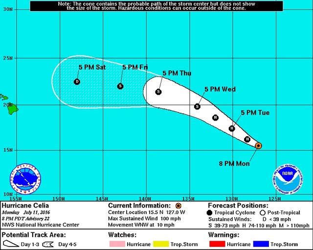
At 5 p.m. Monday, Hurricane Celia was about 1,900 miles east-southeast of Hilo, moving west-northwest at 10 mph. The Category 2 storm was packing maximum sustained winds of 100 mph.
“It’s still a long ways off. It is a system that we’re concerned about because it’s east-southeast of us … and it’s moving more or less towards us,” said Pete Donaldson, an NWS forecaster in Honolulu. “We’re expecting the system is going to be moving towards the west-northwest, so over the next few days, it’s going to be getting closer to us.”
Celia comes on the heels of Blas, a former Category 4 Pacific hurricane that hit cooler water and disorganized into a remnant low-pressure system early Sunday.
“This system will probably have more of an impact than (former Tropical Storm) Agatha, which is minimal impact, or Blas, which might be a little more,” Donaldson said.
With caution, Donaldson noted Celia is also expected to hit cooler water and weaken, “but we’re not looking for that to happen for a little while. Right now, it’s still over warm water and it is strengthening.”
“Once it gets into that cooler water and starts to weaken, it looks like it’s going to weaken pretty steadily before it gets to the islands … and it looks like that’s going to be sometime next week, maybe, Sunday night (or) Monday time frame,” he said.
The National Hurricane Center said in its 5 p.m. advisory Monday the storm’s weakening should start today.
Donaldson said the effect Celia will have on the Islands, Hawaii Island in particular, will largely depend on whether the storm passes to the north of the Big Island, as current computer forecast models project, or to the south, which he said is still a possibility.
“This far out, and we’re talking five or six days, it’s hard to tell exactly where it’s going to be and that makes a big difference to what the weather will be,” he said. “If the system goes far enough north of the Islands and we’re not in the direct wind pattern of the hurricane … it kind of cancels out the tradewinds and we actually end up with lighter winds. … And if it would pass to the south of the Big Island, then the strongest winds would be over the Big Island.
The third possibility, one many on the Big Island said couldn’t happen two years ago, is that Celia could make landfall at hurricane or tropical storm strength, as Tropical Storm Iselle did in early August 2014. Iselle caused millions of dollars in damage, toppling trees, destroying buildings, wreaking havoc on island infrastructure, utilities and agriculture, and interfering with primary election polling.
“If there’s a hurricane or any type of tropical cyclone heading towards the islands, we won’t normally put out a watch until 48 hours before (it’s forecast to hit) or a warning for 36 hours before. That gives people some time to get ready. But the time to prepare is now,” Donaldson said. “If you wait too long to go to the store, batteries are going to be all gone (and) plywood’s going to be all gone. Now is the time to prepare regardless of what the system does.”
The weather service also is keeping an eye on another system, Tropical Depression 5E, developing off the west coast of Mexico.
“You’re talking about a system that’s farther away than Las Vegas at this point, over 3,000 miles, but that’s a reminder that if Celia doesn’t do anything to us, there’s still a possibility that the other one there might,” Donaldson said. “Hurricane season runs through the end of November, so any preparations you do now will be useful for several months to come.”
Email John Burnett at jburnett@hawaiitribune-herald.com.


