Celia has been downgraded from a hurricane to a tropical storm, but another Pacific cyclone, Darby, was upgraded Wednesday to a hurricane, the third of the season. ADVERTISING Celia has been downgraded from a hurricane to a tropical storm, but
Celia has been downgraded from a hurricane to a tropical storm, but another Pacific cyclone, Darby, was upgraded Wednesday to a hurricane, the third of the season.
Both storms are still well east of the Islands.
“We’re in a kind of a pattern of (storms) becoming a hurricane in the sweet spot, and when they move west, away from that nice spot for hurricanes, they’re dying off pretty quick,” said Ian Morrison, a forecaster for the National Weather Service in Honolulu, on Wednesday afternoon.
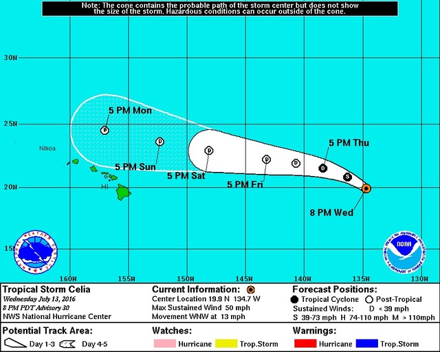
At 5 p.m. Wednesday, Celia was about 1,325 miles east of Hilo, with maximum sustained winds of 50 mph and moving west-northwest at 13 mph. It is forecast to continue weakening as it approaches the Central Pacific sometime tonight, according to the National Hurricane Center.
“NHC has it as a post-tropical remnant low right when it reaches (longitude) 140, so it might not even make it to the Central Pacific as a storm. It might just be a big mass of moisture,” Morrison said.
Remnants of the former Hurricane Blas, which brought elevated surf to the Islands, are still affecting Big Island weather, Morrison said.
“That moisture will come across the Islands (tonight) and into Friday morning. So, we will have some increased, especially windward, showers with that and increased humidity as well,” he said. “The moisture from Celia will make it here sometime late in the weekend, Sunday afternoon or evening. It’s going to be hot and muggy with lighter winds. Depending on how much Celia can hold together, we might see a push of northeast winds on Friday and Saturday. But it’s still going to be quite muggy with all that tropical moisture around. The dew points are going to be in the low 70s (degrees), which is quite humid for us.”
Morrison said higher surf from Celia will hit the Islands before any moisture or possible winds.
“The swell from Celia should start coming in over the next couple of days,” he said. “We will be close to advisory levels (8 feet) when it starts to hit. That looks to come up on Friday. This one might be a little bigger than the one we had the past week with Blas. And it’s a higher-energy swell, so it’s bigger waves than with just a trade wind swell.”
Darby was more than 2,700 miles away east-southeast of the Islands on Wednesday afternoon, about the same distance as Honolulu to Las Vegas. At 5 p.m. Wednesday, it was a Category 1 hurricane, packing maximum sustained winds of 80 mph and moving west at 13 mph.
“It’s going to continue moving to the west with a little bit of north in it. It should intensify, perhaps to 90 knots (about 104 mph) on Friday,” Morrison said. “But it should weaken to a tropical storm before it hits (the Central Pacific).”
Yet another meteorologic disturbance is gathering steam off the southwest coast of Mexico, and the NHC gives it a 40 percent chance of becoming a tropical cyclone within 48 hours.
“If the next one gets named, that one will be Estelle,” Morrison said.
“This year, it’s more difficult for them to come into the Central Pacific because they’re encountering cooler water,” he concluded. “It’s a big change going from one of the strongest El Ninos on record last year and transitioning into neutral and then into La Nina, going into the next year or two. The atmosphere is changing; the water temperature is changing. … That means, for us, the waters to the east of us are not as warm as they were last year. So, that’s less conducive to a hurricane strengthening or even maintaining.”
Email John Burnett at jburnett@hawaiitribune-herald.com.


