Muggy conditions and localized heavy rainfall are a possibility for the Big Island starting Sunday as Tropical Storm Celia approaches the state. ADVERTISING Muggy conditions and localized heavy rainfall are a possibility for the Big Island starting Sunday as Tropical
Muggy conditions and localized heavy rainfall are a possibility for the Big Island starting Sunday as Tropical Storm Celia approaches the state.
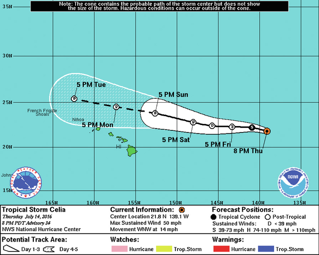
Located 1,045 miles east of Hilo, Celia was circulating 50 mph and trekking west-northwest at 14 mph as of 5 p.m. Thursday, according to the National Hurricane Center. The storm was expected to enter the Central Pacific Basin, where Hawaii is located, late Thursday or early today.
As the storm makes its way toward the Hawaiian Islands, forecasters expect continued weakening thanks to west-northwesterly shear and cooler sea surface temperatures that were around 75 degrees Thursday. It’s likely Celia will be downgraded to a post-tropical remnant low Friday.
Based on current forecast models, Celia is expected to move north of the islands Sunday into early next week. Sunday morning, forecasters say the storm’s remnants will be about 325 miles north-northeast of Hilo.
Current wind speed probabilities, which look forward up to five days, show no chance of tropical storm-force winds impacting the Big Island.
However, that doesn’t mean the island is safe from any impacts, said Tom Birchaud, a hurricane specialist with the National Weather Service in Honolulu. With most of the wind and power of the storm located north of its center, winds will drop dramatically, almost to zero in the islands.
“That is what will make it feel especially muggy — it will be just this sort of pool of moisture coming across, ” he said. “Sunday and Monday look particularly muggy and that moisture is what could fuel those heavy showers.”
Those showers will mainly occur over the island’s slopes, he said. The heating of the island combined with the enhanced moisture will likely bring rainfall to the leeward side of the island.
In 2015, storms passing north and south of the Big Island resulted in heavy rainfall that prompted flooding in areas of West Hawaii.
A flood advisory may be posted for the island later this weekend, he said.
The storm is also expected to bring advisory-level surf to east-facing shores late Friday through the weekend.
Moderate trade winds are expected to return Tuesday, Birchaud said.
Celia will be the first storm to impact the Central Pacific basin this season. Forecasters had called for four to seven storms to pass through the basin, which covers an area between 140 degrees west longitude and the International Date Line.
Behind Celia is Hurricane Darby and another area of disturbed weather closer to Mexico.
“We’re getting close to August, the heart of the tropical cyclone season in the Pacific,” Birchaud said.
“It did start slowly, but it’s been sort of a parade for the past two weeks or so, and forecast models are indicating there’s more behind the system.”
Darby was located 2,400 miles east-southeast of Hilo and was circulating 90 mph winds and traveling west at 13 mph as of Thursday evening. Little chance in strength was expected today and gradual weakening is forecast thereafter.
Birchaud said the storm will likely cross into the Central Pacific basin on Tuesday.
Current forecast models indicate it will be a tropical storm packing 60 mph winds at that time.


