Remnants of Tropical Storm Celia brought heavy but localized rains to the Big Island this week, with places such as Laupahoehoe receiving more than 3 inches in a 24-hour period. ADVERTISING Remnants of Tropical Storm Celia brought heavy but localized
Remnants of Tropical Storm Celia brought heavy but localized rains to the Big Island this week, with places such as Laupahoehoe receiving more than 3 inches in a 24-hour period.
“As it was passing by to the north, it did help drag up some tropical moisture over the state,” National Weather Service meteorologist Bob Burke said Tuesday.
The localized rain occurred because of a different type of trade wind pattern that is more unstable than typical patterns. In a typical trade wind inversion, clouds form at about 8,000 feet. This week, the cloud systems developed at about 15,000 feet.
Wind patterns are expected to return to normal now that Celia passed by, with rainfall resuming its regular trade wind distribution.
“Most of the showers will be your typical windward showers,” Burke said.
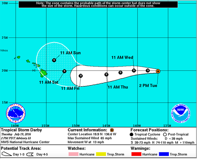
Tropical Storm Darby continues to move closer to Hawaii, but is a “rather small system,” Burke said.
The National Hurricane Center in Miami is forecasting a northward curve for Darby, meaning it would have little impact on Hawaii Island.
“Sometimes you can get some outer rain bands interacting with the terrain,” Burke said about the smaller systems. The effects of that interaction would show up this weekend, he said.
Last year’s hurricane season was a busy one in the Central Pacific basin, but so far that has not been the case for 2016.
“Last year, a lot of the systems were forming closer to us, or in our basin,” Burke said. A similar number of Pacific systems have formed, but “We’ve had nothing in the Central Pacific,” he said. “The only things we’ve had are these systems moving into our basin.”
Tropical Storm Estelle is currently the only other named system in the Eastern Pacific, and is not expected to affect Hawaii.
By the time a system from the Eastern Pacific makes its way closer to Hawaii, it typically has weakened because of colder waters.
“Darby’s already weakened,” Burke said. “It was a hurricane (Monday).”
The movement into cooler waters didn’t happen as frequently last year because El Nino patterns kept water surface temperatures warmer than usual, allowing storm systems to thrive for longer periods.
It also created record-setting temperatures. Last July, Hawaii was in the midst of a month-long record-setting heat wave, with temperatures peaking at 90 degrees.
“When the surface temperatures are warm around the Islands, even your typical cooling trade winds aren’t going to be as cool,” Burke said. “That had a big effect not just on the tropical cyclones but on our local weather patterns.”
Email Ivy Ashe at iashe@hawaiitribune-herald.com.


