“Be prepared for a possibly wet weekend.” ADVERTISING “Be prepared for a possibly wet weekend.” That was the advice of Matt Foster, a National Weather Service forecaster in Honolulu when asked Thursday afternoon about the effect
Tropical Storm Ulika is
“Be prepared for a possibly wet weekend.”
That was the advice of Matt Foster, a National Weather Service forecaster in Honolulu when asked Thursday afternoon about the effect
Tropical Storm Ulika is likely to have on East Hawaii.
“There will probably be some increase in showers, but there is some (computer) model discrepancy as to how widespread it’s going to be,” Foster said.
“The models certainly bring it near us putting it by this trough (low-pressure system) aloft as it passes by the islands, but by that time, it should be just a remnant system without any kind of organization to it. It should be just an increase in showers this weekend and going into early next week.”
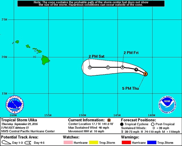
At 5 p.m. Thursday, Ulika remained a tropical storm, but just barely.
The cyclone’s center was about 930 miles east of Hilo, with maximum sustained winds of 40 mph, and moving to the northwest at 10 mph.
Tropical storm-force winds extended outward up to 35 miles from the center.
No coastal watches or warnings were in effect.
Ulika was forecast to steadily weaken and become a remnant low-pressure system as early as today. Still, Foster said, it could put a damper on outdoor plans for the weekend.
“That upper-level trough interacting with the remnant of Ulika might bring heavier showers than typical tradewind-type stuff,” he said, and noted Saturday is the official start of the islands’ rainy season.
The storm could cause an increase in wind and surf, Foster said, but added, “I doubt it’s going to amount to much.”
Email John Burnett at jburnett@hawaiitribune-herald.com.


