KAILUA-KONA — The U.S. Army Corps of Engineers soon will begin work to determine the extent of munitions and explosives of concern remaining from military training and on more than 1,900 acres on Kohala Mountain’s flanks. ADVERTISING KAILUA-KONA — The
KAILUA-KONA — The U.S. Army Corps of Engineers soon will begin work to determine the extent of munitions and explosives of concern remaining from military training and on more than 1,900 acres on Kohala Mountain’s flanks.
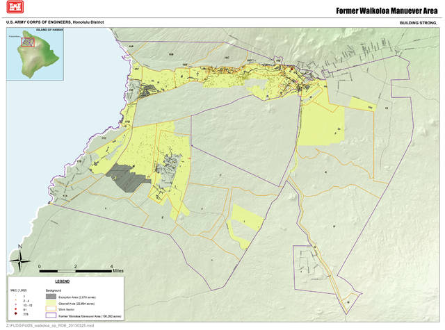
The land is within the Former Waikoloa Maneuver Area, an area that covers 123,000 acres on Hawaii Island’s northwest side of the Big Island and served as a military camp and artillery range for thousands of troops between 1943 and 1945.
To date, more than 100 different types of munitions have been found within the maneuver area, including mortars, projectiles, hand grenades, rockets, land mines and Japanese ordinances. Corps contractors working with metal detectors have removed thousands of pounds of munitions debris, and 2,400 pieces of ordnance from more than 28,000 acres over decades of cleanup.
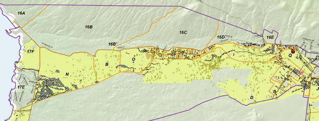
Corps’ crews will in the coming months begin to evaluate the extent of items remaining on two tax map key parcels mauka of Kawaihae Road.
The area, identified as 16C, is situated between Kohala Mountain and Kawaihae roads, starting south of Waiemi Place and heading mauka to the vicinity of mile marker 61 of Kawaihae Road in South Kohala. The acreage is mainly pastureland, however, several utility easements sit on about 2.5 acres.
The corps recently got approval to enter the state land from the Board of Land and Natural Resources after members voted unanimously Feb. 24 to approve issuing the a right-of-entry permit through the corps, which is the executing agency for “remedial investigation/feasibility studies.”
“Crews will evaluate the presence of munitions and explosives of concern (MEC), and conduct appropriate actions to respond to and mitigate hazardous conditions from unexploded ordnance (UXO),” Dino W. Buchanan, chief public affairs officer for the corps’ Honolulu District, said in an email.
The subject parcels had previously been included in a DERP/FUDS project under a five-year right-of-entry permit that expired July 31, according to submittals to the Land Board. The corps did not get to the parcels because funding was not made available for the investigation/study prior to an old permit’s expiration date in July 2016.
The permit approved Feb. 24 gives the corps a year to complete the work.
Field investigation work, once commenced, shouldn’t take more than two months to complete. The public will get its chance to chime in on the cleanup effort later next year when the corps’ completes a required proposed plan summarizing the remedial alternatives for a project and the preferred cleanup method to go for public and agency review and comment. Based on the current schedule, Buchanan expects the plan to be made available in late 2018.


