Volcano Watch: HVO’s website makeover more than skin deep

In 1998, a U.S. first-class postage stamp cost 32 cents and a gallon of gas in Hawaii set you back about $1.50. Apple unveiled the iMac, Google was founded and Pokémon was released in the U.S. for Nintendo® Game Boy.
ADVERTISING
Fast forward to 2017. Email and paying bills online have all but replaced the need to mail a letter for 49 cents. The price of gas has doubled, but it’s now possible to opt for an electric car and never go to the pump. And amazingly, many people carry a pocket-sized computer (a smartphone) with the capability to search the internet for whatever they want, any time of the day — or just play Pokémon GO.
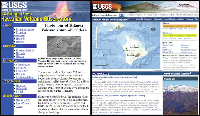
Why compare 1998 to 2017? It’s related to the USGS Hawaiian Volcano Observatory website, which was launched in March 1998. Not much changed through the course of 19 years — until last week, when an extensive makeover of the website was rolled out.
The changes to HVO’s website are much more than “skin” deep — its “bones” are completely different.
What you now see on your computer or mobile device is supported by a powerful database that houses informational content and nearly all volcano monitoring data that stream into HVO from hundreds of instruments throughout Hawaii. This new structure allows for a more efficient and consistent website, with simplified maintenance that leads to fewer broken links.
Written sections were added and expanded to explain the eruption history of many Hawaiian volcanoes. But the real stars of the new website are the interactive maps that display earthquake and monitoring data.
On HVO’s old site, you could only see data from seismometers and a few deformation instruments on Kilauea and Mauna Loa. The new map interface allows access to more data types, and you can view near-real-time data streams from all our monitored volcanoes by clicking on the instrument symbols.
The maps can be reached via “Earthquakes” in the website menu bars, or via the “Monitoring” tab in submenus on the Kilauea and Mauna Loa volcano pages.
Sharing results of monitoring and scientific study is a primary goal of HVO scientists. Kilauea Volcano’s Pu‘u ‘O‘o eruption was in its 15th year when HVO’s first website was launched and the internet made it easier to share information about it.
With the advent of the HVO website came detailed daily updates of Kilauea eruptive activity. Field photographs were regularly posted (and even back-dated to 1997) on the website. In 2000, scientists began posting maps of the East Rift Zone lava flows. Through HVO’s website, the eruption of Kilauea reached a growing and devoted worldwide audience.
Advances in technology and volcano monitoring capability led to more enhancements to the website.
In 2003, HVO scientists built a powerful volcano-monitoring data analysis and visualization tool called “VALVE.” By 2006, deformation data (tilt and GPS) that record the up-and-down movement (inflation and deflation) of Kilauea’s summit and Pu‘u ‘O‘o crater were made available on the HVO website. Webcam images were then added steadily — Pu‘u ‘O‘o in 2004, Mauna Loa in 2005, Halema‘uma‘u in 2008 — with a dedicated page for webcams created in 2009.
In 2011, the hard-coded HTML pages for images, videos and Volcano Watch articles were transitioned into a database. Although what you saw on your computer didn’t change dramatically, the database made it much easier to post, manage and archive information.
In the same year, HVO launched its first interactive map (VolcWeb) to display earthquake monitoring data for Hawaiian volcanoes. The 2017 website map improves and enhances the information available, especially for mobile devices.
Conceptualization for the redesign of HVO’s website began six years ago. The longstanding history and large audience for HVO’s online presence were carefully considered in the development of the new website. Its architecture allows for continual and easier improvements, which are ongoing and will take into account how users interact with the website.
Change is rarely easy, and it takes time to adapt to something new. We hope once you explore HVO’s new website and learn the pathways to your favorite content, you’ll find gems along the way and enjoy learning more about Hawaiian volcanoes.
Feedback about the website is welcome at askHVO@usgs.gov.
Volcano activity updates
This past week, Kilauea’s summit lava lake fluctuated in concert with summit inflation and deflation, with levels ranging about 15 to 28 m (49 to 92 ft) below the vent rim. On the East Rift Zone, the 61g flow remained active, with lava entering the ocean near Kamokuna and surface breakouts downslope from Pu‘u ‘O‘o. These flows do not pose an immediate threat to nearby communities.
Mauna Loa is not erupting. During the past week, small-magnitude earthquakes were recorded mostly beneath the summit caldera and upper Southwest Rift Zone at depths up to 5 km (3 mi). Microearthquakes also occurred on the east flank of the volcano at depths of 5 to 13 km (3 to 8 mi). GPS measurements continue to show deformation consistent with inflation of a magma reservoir beneath the summit and upper Southwest Rift Zone. No significant changes in volcanic gas emissions were measured.
Two earthquakes were reported felt on the Island of Hawaii during the past week. At 2:53 p.m. May 15, a magnitude-2.6 earthquake occurred 16 km (10 mi) west of Waikoloa Village at a depth of 42 km (26 mi). At 4:47 p.m. May 11, a magnitude-3.5 earthquake occurred 8 km (5 mi) northeast of Pahala at a depth of 34 km (21 mi).
Visit the HVO website (https://volcanoes.usgs.gov/observatories/hvo/) for past Volcano Watch articles, Kilauea daily eruption updates, Mauna Loa weekly updates, volcano photos, recent earthquakes info, and more; call for summary updates at 808-967-8862 (Kilauea) or 808-967-8866 (Mauna Loa); email questions to askHVO@usgs.gov.
Volcano Watch (https://volcanoes.usgs.gov/observatories/hvo/hvo_volcano_watch.html) is a weekly article and activity update written by U.S. Geological Survey Hawaiian Volcano Observatory scientists and colleagues.


