Kilauea has now passed the one-year anniversary of the episode 61g lava flow reaching the Pacific Ocean. But what was this busy volcano up to a decade ago? Were things as dynamic as they are now?
Absolutely!
Slightly more than 10 years ago — on July 21, 2007 — episode 58 of the ongoing East Rift Zone eruption got underway with a dramatic collapse of the Pu‘u ‘O‘o crater floor. At the same time, new fissures opened high on the northeastern flank of Pu‘u ‘O‘o. These fissures unzipped the ground and erupted lava to the northeast as far as the 1986-92 Kupaianaha lava shield, about 3 km (2 mi) downrift.
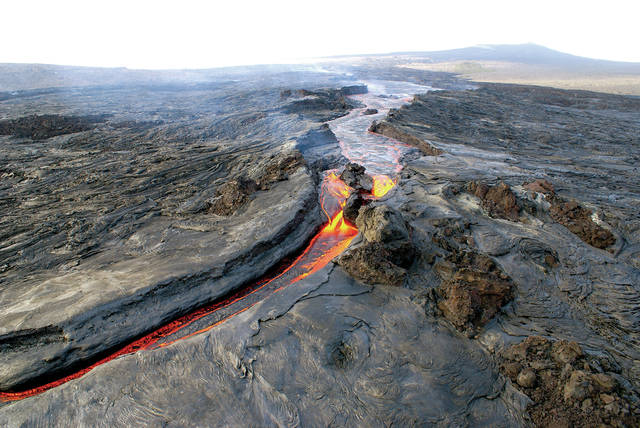
Activity soon became localized at the northeastern end of the new fissures. This vent, called Fissure D, produced a series of short-lived ‘a‘a flows. By late August, the open lava channel feeding the ‘a‘a flows began to overflow its banks.
The overflows raised the enclosing levees to form a “perched” lava channel that eventually stood about 45 m (150 ft) above the pre-existing ground.
This feature was somewhat unusual in that it represented a cross between an elongate lava channel and a lava lake. Perched lava ponds or lakes are formed by a similar process, with periodic overflows raising the levees and elevating the pool of molten lava above its surroundings. This process has been observed only once with Kilauea Volcano’s current lava lake at Halema‘uma‘u, but the phenomenon was common at summit lava lakes in the late 1800s and early 1900s.
The episode 58 perched lava channel provided some interesting observations of “seeps,” as they were called by USGS Hawaiian Volcano Observatory geologists. The seeps, extrusions of sticky lava through the enclosing levees of the perched channel, produced short toothpaste-like flows adjacent to the channel.
Another early phase of episode 58 produced “rootless shields” south of Pu‘u ‘O‘o. These broad, gently sloped accumulations (shields) of lava are called “rootless” because they are not situated over primary eruptive vents. Some of the rootless shields collapsed with time, providing new insights into the formation and destruction of these structures. Similar structures and related lava flows also have been reported in Iceland and recognized in satellite images of Mars.
Lava from episode 58 eventually formed a stable tube system that extended to the southeast and reached the ocean March 5, 2008. This ocean entry was called Waikupanaha, which was about 3.9 km (2.4 mi) east of today’s Kamokuna ocean entry.
Episode 58 endured until March 5, 2011. It was significant in several ways, primarily for increasing our understanding of Kilauea and its volcanic processes.
It also was the first East Rift Zone eruption episode to occur simultaneously with an eruption at the summit of Kilauea — the Overlook vent and lava lake within Halema‘uma‘u, which opened in March 2008. Such synchronous eruptive vents separated by 20 km (12 mi) continue today.
The two ongoing eruptions offer tremendous opportunities to study the hydraulics of the magma plumbing and transport system between the summit and east rift of Kilauea.
Episode 58 ended when the shallow conduit carrying lava from the main reservoir beneath Pu‘u ‘O‘o to the Fissure D vent became plugged. This caused a backup between Pu‘u ‘O‘o and the summit magma reservoir, providing another data point in how the two parts of Kilauea Volcano’s plumbing system influence each other.
Time-lapse images obtained by remote HVO cameras prior to and during episode 58 were compiled in a series of movies to illustrate Kilauea in action.
These short Quicktime files can be freely downloaded from the U.S. Geological Survey at https://pubs.usgs.gov/ds/621/ds621.pdf.
As the episode 61g lava flow enters its second year, HVO continues to track and study the dynamic processes of Kilauea, one of the world’s most active volcanoes. Only time will tell what the next decade will bring.
Volcano activity updates
This past week, Kilauea Volcano’s summit lava lake level fluctuated in concert with summit inflation and deflation, ranging from 31-48 m (102-157 ft) below the vent rim. On the East Rift Zone, the 61g flow remained active, with lava entering the ocean near Kamokuna and surface breakouts downslope of Pu‘u ‘O‘o. Widening cracks and slumping on the Kamokuna lava delta indicate its instability and potential for collapse.
The 61g flows do not pose an immediate threat to nearby communities.
Mauna Loa is not erupting. During the past week, small-magnitude earthquakes continued to occur beneath the volcano, primarily in the south caldera and upper Southwest Rift Zone, at depths of less than 5 km (3 mi). GPS measurements continue to show deformation related to inflation of a magma reservoir beneath the summit and upper Southwest Rift Zone.
No significant changes in volcanic gas emissions were measured.
Two earthquakes with three or more felt reports occurred on the Island of Hawaii during the past week.
At 3:54 a.m. Aug. 3, a magnitude-3.4 earthquake located 3 km (2 mi) southwest of Captain Cook occurred at a depth of 11 km (7 mi). At 2:01 a.m. July 30, a magnitude-4.2 earthquake located 33 km (21 mi) northwest of Hawi occurred at a depth of 17 km (11 mi).
Visit the HVO website (https://volcanoes.usgs.gov/hvo) for past Volcano Watch articles, Kilauea daily eruption updates, Mauna Loa weekly updates, volcano photos, recent earthquakes info, and more.
Call for summary updates at 808-967-8862 (Kilauea) or 808-967-8866 (Mauna Loa). Email questions to askHVO@usgs.gov.
Volcano Watch (http://hvo.wr.usgs.gov/volcanowatch/) is a weekly article and activity update written by U.S. Geological Survey Hawaiian Volcano Observatory scientists.


