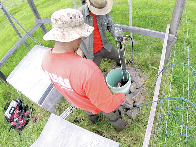
Creative engineering helps HVO monitor Mauna Loa Volcano

The USGS Hawaiian Volcano Observatory has a long tradition of innovation when it comes to the tools we use to monitor the status and activity of volcanoes.
ADVERTISING
Since HVO’s inception in 1912, observatory staff have developed techniques and manufactured instruments that have been used worldwide for volcano monitoring.
The tradition continues to this day, with HVO continually adapting and creating equipment and methods in response to changing conditions and to take advantage of new technologies. For example, a recent equipment installation challenge was met with enthusiasm as an opportunity to design and implement new tools.
The challenge was presented by a malfunctioning tiltmeter in a deep borehole on the west flank of Mauna Loa Volcano. The tiltmeter, which was originally installed 17 years ago, had a long and fruitful career before giving up.
But we were not ready to let go of the data it provided, especially considering how restless Mauna Loa has been during the past few years.
This particular installation is part of a network of several deep sites on Mauna Loa that include seismometers, tiltmeters and strainmeters. These extremely sensitive instruments are housed in boreholes more than 15 m (50 ft) deep to help isolate them from the effects of temperature, rainfall and atmospheric pressure fluctuations, all of which can cause spurious signals.
The tiltmeter itself is a metal tube, 1 m (3 ft) long and 5 cm (2 in) in diameter that contains precision electrolytic sensors that detect tiny tilt variations in two perpendicular directions. It can measure tilts smaller than 1 microradian, which is about the same as the slope created by putting a dime under one end of a board that is 1 km (more than half a mile) long.
Now imagine lowering that tube about 15 m (50 ft) into a 10 cm (4 in) diameter hole that also has a bunch of cables (from the strainmeter, seismometer, and old tiltmeter) snaking up through it. You also have to position the tiltmeter so it stays upright and doesn’t rest on any of those cables or the sides of the hole while you pour sand to keep it in place.
Pretty tough, right?
But the challenge continues.
Now add the requirement that you must orient the tiltmeter so its sensors are aligned to north-south and east-west directions, or at least know the exact direction to which those sensors are pointing. This calls for some rather heroic feats of engineering.
The solution HVO’s technical crew came up with was to use computer-assisted drawing software to design a specialized jig that sits around the tiltmeter and gently channels all the cables out of the way while the instrument is lowered into the borehole.
The jig was manufactured using a 3-D printer, which put down layer after layer of thermoplastic to build a solid object with customized specifications.
Another specially built apparatus holds the jig, the tiltmeter, a light and a video camera that provides a real-time view of the tiltmeter’s descent as it is lowered into the borehole and positioned at the bottom.
We’re glad to report that the installation was successful and the new tiltmeter is now faithfully recording ground tilt on the west flank of Mauna Loa. These data are sent back to the observatory via radio links so HVO gets them in less than a minute.
Our hope is that this tiltmeter will help provide the earliest possible warning of rapid magma movement toward the surface, which would signal an impending Mauna Loa eruption. We also hope these data will help us understand the processes and conditions that lead to eruptions so we can continue to advance the field of eruption forecasting.
Whatever the outcome, the innovation of HVO’s technicians will continue to be valuable well into the future, in Hawaii and abroad.
Volcano activity updates
This past week, Kilauea Volcano’s summit lava lake level fluctuated in concert with summit inflation and deflation, ranging from about 35-43 m (115-140 ft) below the vent rim.
On the East Rift Zone, the 61g flow remained active, with lava entering the ocean near Kamokuna and surface breakouts downslope of Pu‘u ‘O‘o. Widening cracks and slumping on the Kamokuna lava delta indicate its instability and potential for collapse.
On Aug. 19, a short-lived breakout about 120 m (400 ft) inland of the delta formed a cascade of lava over the sea cliff and onto the western delta surface; this activity lasted less than 10 hours. The 61g flows do not pose an immediate threat to nearby communities.
Mauna Loa is not erupting. During the past week, small-magnitude earthquakes continued to occur beneath the volcano, primarily in the south caldera and upper Southwest Rift Zone, at depths of less than 5 km (3 mi).
Additional deeper events (5-13 km, or 3-8 mi) occurred beneath the upper west and southeast flanks of the volcano. GPS measurements continue to show deformation related to inflation of a magma reservoir beneath the summit and upper Southwest Rift Zone. No significant changes in volcanic gas emissions were measured.
One earthquake with three or more felt reports occurred in the Hawaiian Islands during the past week: at 8:35 p.m. Aug. 18, a magnitude-4.1 earthquake located 107 km (66 mi) northeast of Hawaiian Beaches and 30 km (19 mi) deep.
Visit the HVO website (https://volcanoes.usgs.gov/hvo) for past Volcano Watch articles, Kilauea daily eruption updates, Mauna Loa weekly updates, volcano photos, recent earthquakes info, and more. Call for summary updates at 808-967-8862 (Kilauea) or 808-967-8866 (Mauna Loa). Email questions to askHVO@usgs.gov.
Volcano Watch (http://hvo.wr.usgs.gov/volcanowatch/) is a weekly article and activity update written by U.S. Geological Survey Hawaiian Volcano Observatory scientists.


