Volcano Watch: Legacy of Mount St. Helens 1980 eruption still defies perfect solution

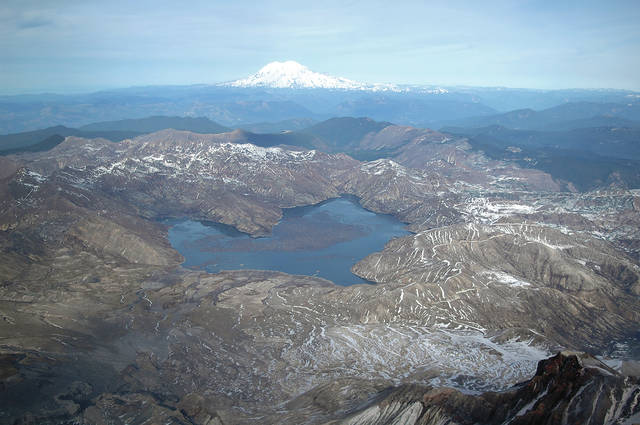
Thirty-seven years after the May 18, 1980, eruption of Mount St. Helens in Washington, scientists, engineers, land managers and federal, state and county officials are still grappling with a challenge created by the eruption — how to prevent potentially massive downstream flooding by the release of water from Spirit Lake, located at the base of the volcano.
ADVERTISING
A new report published this summer by the U.S. Forest Service describes the complex and interrelated natural hazards — volcanic, seismic and hydrologic — and risks associated with several options to manage the water level of Spirit Lake (www.fs.usda.gov/treesearch/pubs/54429). The USFS is the agency charged with management of Mount St. Helens National Volcanic Monument, including an engineered outlet for Spirit Lake.
The 1980 eruption began with an enormous landslide, released as a series of massive blocks of rock and ice from the volcano. Most of the sliding debris sped 22 kilometers (13.7 miles) down the North Fort Toutle River, filling the valley to an average depth of about 45 meters (148 feet) in about 10 minutes.
Part of the landslide slammed into Spirit Lake, blocking its natural outlet and raising the lake level by 60 meters (197 feet). In the area between Spirit Lake and the North Fork Toutle River to the west, the landslide deposit is as thick as 195 meters (640 feet).
Without an outlet, the lake rose with each rainstorm and seasonal snowmelt. By August 1982, the lake level had risen an additional 16.5 meters (54 feet). At that filling rate, water was projected to possibly breach the blockage and produce a catastrophic flood by 1985. Such a flood would likely lead to loss of life and extensive damage (more than $1 billion) in communities downstream along the Toutle, Cowlitz and Columbia rivers.
To mitigate this potential flood hazard, on Aug. 19, 1982, former President Ronald Reagan directed the Federal Emergency Management Agency to develop a strategy to prevent breaching of the landslide blockage. While various outlet alternatives were proposed and studied, a temporary pumping facility was installed to lower and stabilize the lake level.
Ultimately, the U.S. Army Corps of Engineers constructed a tunnel 2.6 kilometers long (8,500 feet) and 3.4 meters in diameter (11 feet) through a bedrock ridge on the west side of Spirit Lake to deliver its water back into the North Fork Toutle River. The tunnel has successfully controlled the lake level since 1985.
However, several major and costly repairs to the tunnel, owing to damage caused by surrounding rock squeezing it, were necessary in 1995, 1996 and 2016. Additional repairs are expected in the future.
When sections of the tunnel are repaired or upgraded, the tunnel is closed for many months. Repairs always happen during the winter rainy season to ensure adequate streamflow downstream for fish. With the tunnel closed, the lake level rises, and during each repair water approached its maximum “safe” level.
Such high water levels raise concern. If the lake rises only a few meters (yards) higher than it has during prior repairs, for example during an exceptional weather event coincident with an extended tunnel closure, the consequences could be “severe,” according to the USFS report.
To address this concern, an interagency task force evaluated risks associated with the current tunnel and alternative outlets. The new report summarizes those potential risks, including those to an engineered open channel just below the volcano’s north-facing crater, an option exposed to volcanic events that could block or damage the channel, and a buried pipe through the chaotic landslide deposit.
Another much-anticipated report is expected soon from the National Academy of Sciences, Engineering and Medicine (dels.nas.edu/Study-In-Progress/Long-term-Management-Spirit/DELS-BESR-15-03). This report will focus on a “framework for technical decision-making related to the long-term management of risks related to the Spirit Lake/Toutle River system” and take into consideration “regional economic, cultural and societal priorities.”
As yet, the USFS has not made any decisions regarding a new outlet strategy. The new reports will help inform such decisions given the volcanic, seismic and hydrologic hazards that threaten each alternative as well as the long-term costs.
Volcano Activity Updates
This past week, Kilauea Volcano’s summit lava lake level fluctuated with summit inflation and deflation and ranged about 34-53 meters (112-174 feet) below the vent rim.
On the East Rift Zone, the 61g flow remained active, with lava entering the ocean near Kamokuna and surface breakouts downslope of Pu‘u ‘O‘o. Active lava flows and a small collapse were observed on the Kamokuna lava delta this week, and it remains unstable, with potential for larger collapses. The 61g flows do not pose an immediate threat to nearby communities.
Mauna Loa is not erupting. During the past week, small-magnitude earthquakes continued to occur beneath the summit caldera and upper Southwest Rift Zone, primarily at depths less than 5 kilometers (3 miles), with some additional deeper events (5-13 kilometers, or 3-8 miles). GPS measurements continue to show deformation related to inflation of a magma reservoir beneath the summit and upper Southwest Rift Zone.
No significant changes in volcanic gas emissions were measured.
No earthquakes were reported felt in the Hawaiian Islands during the past week.
Visit the HVO website (https://volcanoes.usgs.gov/hvo) for past Volcano Watch articles, volcano updates and photos, recent earthquake info, and more. Call for summary updates at 967-8862 (Kilauea) or 967-8866 (Mauna Loa). Email questions to askHVO@usgs.gov.
Volcano Watch (http://hvo.wr.usgs.gov/volcanowatch/) is a weekly article and activity update written by U.S. Geological Survey Hawaiian Volcano Observatory scientists.


