UPDATE at 5:13 p.m.
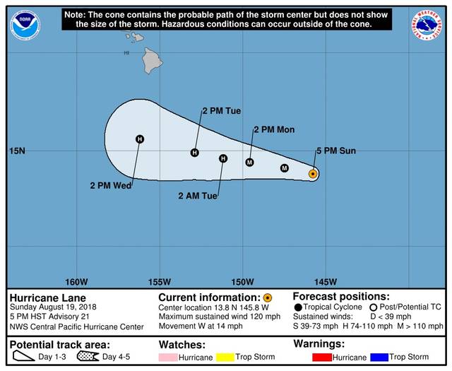
As of 5 p.m. today, the center of Hurricane Lane was about 735 miles southeast of Hilo.
The storm, still a Category 3 hurricane, was packing maximum sustained winds of 120 mph and moving west at 14 mph.
According to forecasters at the Central Pacific Hurricane Center, Lane’s movement is expected to gradually become west-northwest through Tuesday. A gradual slowing in forward speed is also expected through Tuesday.
Hurricane-force winds extend outward up to 25 miles from the center and tropical-storm-force winds extend outward up to 105 miles, forecasters said.
A large swell generated by Lane is expected to reach the southeast and east facing shores of the Big Island, and possibly
east facing shores of Maui, overnight. This swell may produce large and dangerous surf along these shorelines starting early Monday.
—————————————————-
PREVIOUS:
UPDATED at 11:18 am.:
At 11 a.m. today, the center of Hurricane Lane was about 815 miles east-southeast of Hilo.
The storm had intensified slightly since the last report, with maximum sustained winds of 125 mph with stronger gusts, traveling west at 14 mph. The westward track is forecast to continue through today.
Lane is expected to move westward to west-northwestward through Monday night, but at a slightly slower forward speed.
Hurricane-force winds extend outward up to 25 miles from the center and tropical-storm-force winds extend outward up to 105 miles, forecasters said.
ORIGINAL:
Hurricane Lane continues to pack Category 3 storm winds as it continues its westward trek toward Hawaiian waters.
As of 8 a.m. today, the center of Lane was about 850 miles east-southeast of Hilo, with maximum sustained winds of 120 mph and higher gusts, moving west at 15 mph. Slight weakening is possible later today or tonight, but Lane will likely remain a powerful hurricane through Monday night, according to forecasters at the Central Pacific Hurricane Center.
No watches or warnings are have been issued.
A National Oceanographic and Atmospheric Administration G-IV aircraft plans to do sampling in the environment around the Hawaiian Islands and Hurricane Lane today. Forecasters say the data collected during this mission will be available to better initialize the forecast models.
Lane is forecast to pass south of the main Hawaiian Islands Wednesday and Thursday, potentially causing local impacts as it tracks west-northwestward. Residents and visitors should watch
the progress of Lane closely, since long-range track and intensity forecast errors can be large, forecasters say.
Email John Burnett at jburnett@hawaiitribune-herald.com.

