UPDATED 5 p.m.
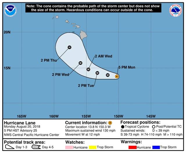
Hurricane Lane is now approximately 515 miles southwest of Hilo, generating maximum sustained winds of 130 miles per hour.
A public notice from the National Weather Service reported that the storm is expected to turn more toward the northwest on Wednesday. A gradual weakening trend is expected to begin after 24 to 36 hours.
UPDATED 11 a.m.
Hurricane Lane strengthened to a Category 4 hurricane this morning and continues on a projected path reminiscent of the route taken by Hurricane Iniki in 1992.
PREVIOUSLY
Hurricane Lane has become more of a concern to officials as the Category 3 storm has taken a northward turn.
“It’s showing a significant swing to the north as it kind of makes its way around the Big Island,” Talmadge Magno, Hawaii County Civil Defense Administrator said this morning. “So we’re concerned that it might bring impacts — definitely waves, not sure yet about what kind of winds or how much rain we’re going to get.”
As of 5 a.m., Lane was about 615 miles southeast of Hilo, packing maximum sustained winds of 125 miles an hour with higher gusts. The storm is moving to the west at 14 mph. Hurricane-force winds extend outward up to 30 miles from the storm’s center and tropical-storm-force winds extend outward up to 120 miles.
Little change in strength is expected through early Tuesday, with some weakening possible starting late Tuesday.
Forecasters at the Central Pacific Hurricane Center said that residents and visitors on all islands should continue to closely monitor the progress of Lane this week. On the current forecast track, a tropical storm or hurricane watch may be required for parts of Hawaii later today or tonight.
A high surf advisory has been issued for east-facing shores from Ka‘u to Puna.
“It’s still building right now. It’s going to build throughout the day,” Magno said. “For today’s forecast, about 10 feet, but as it gets closer, it’s going to get a little bit bigger.”
Magno said those along the affected shorelines should be alert for high and dangerous surf conditions and boat owners should take measures to secure their vessels.
All schools and roads remain open at this time.
Lane is still forecast to pass south of the Big Island, but Magno reiterated that the island could experience some effects from the powerful storm.
“We are in hurricane season,” Magno said. “We had a close one over a week ago with Hector. This one’s got us a little more concerned, because the forecast is not as precise as Hector. So you should be prepared. Have your family plans and your business plans updated, at least. And we’ll be messaging folks after each National Weather Service forecast to let them know what impacts we’re looking at. So just stay tuned.”
Email John Burnett at jburnett@hawaiitribune-herald.com.


