Norman re-strengthens to Category 4 storm, continues toward Central Pacific


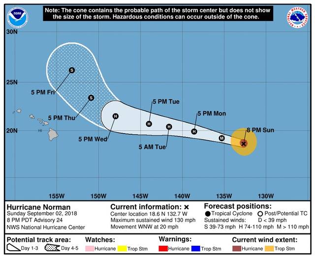
Hurricane Norman has re-strengthened into a Category 4 hurricane as it churns its way toward the Central Pacific.
As of 5 p.m. today, Norman was about 1,460 miles east of Hilo, carrying maximum sustained winds of 130 mph and moving west-northwest at 20 mph. Hurricane-force winds extend outward up to 35 miles from the center and tropical-storm-force winds extend outward up to 115 miles.
ADVERTISING
Gradual weakening of the storm and gradual weakening of its forward speed are expected during the next few days.
Norman is expected to remain a hurricane, although not a major one, as it crosses over the 140 West longitude line into the Central Pacific, which it’s forecast to do either late Monday night or early Tuesday morning.
On its current forecast track, Norman is projected to be a tropical storm when it passes to the northeast of the island sometime on Thursday. It is expected to pass considerably closer to the Big Island than Post-Tropical cyclone Miriam. The remnant low-pressure system as of 5 p.m. today was 810 miles northeast of Hilo with maximum sustained winds of 35 mph.
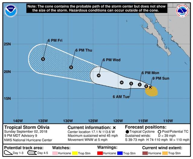
Another tropical cyclone, Tropical Storm Olivia, is brewing in the Eastern Pacific. As of 5 p.m. today, Olivia is about 465 miles south-southwest of the southern tip of Mexico’s Baja California peninsula.
Olivia was packing maximum sustained winds of 45 mph moving west-northwest at 5 mph. This general motion is expected to continue through early Monday. A turn toward the west and some increase in forward speed is expected by Monday night or Tuesday.
Some strengthening is forecast during the next few days, and Olivia could become a hurricane on Tuesday. The cyclone is expected to weaken back to tropical storm status before crossing into the Central Pacific, probably on Saturday.
Email John Burnett at jburnett@hawaiitribune-herald.com.


