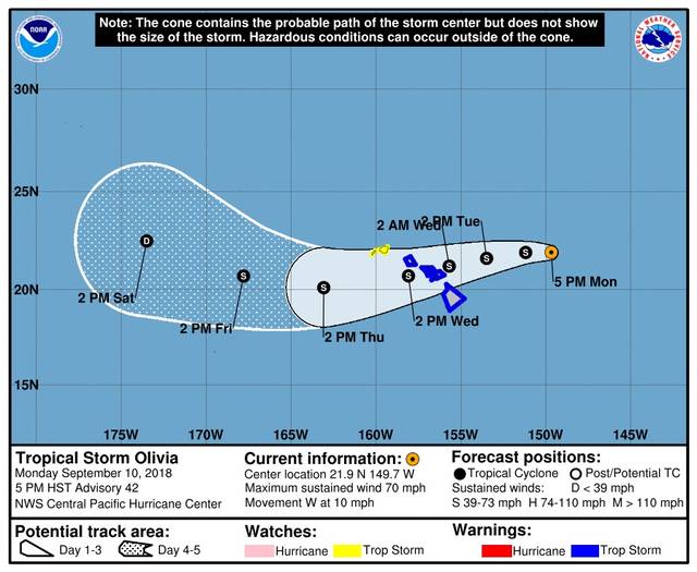
UPDATE 5 p.m.: At 5 p.m., Tropical Storm Olivia was about 380 miles east-northeast of Hilo, packing maximum sustained winds of 70 mph and moving west at 10 mph.
The National Weather Service has posted a high surf warning for the east-facing shores of the Big Island and Maui.
UPDATE: 2:41 p.m: Olivia weakened to a tropical storm Monday afternoon as the cyclone continues to move toward the Hawaiian Islands.
As of 2 p.m. Monday, the center of Olivia was located 415 miles east-northeast of Hilo and tracking west at 9 mph. It was circulating 70 mph winds with higher gusts.
Also Monday, the state Department of Land and Natural Resources announced the closure at noon Tuesday of all Division of Forestry and Wildlife lands on the Big Island and in Maui County. Those lands include all forest reserves, natural area reserves, game management areas, wildlife sanctuaries, public hunting areas and Na Ala Hele trails.
The department will also close all state parks in East Hawaii at noon Tuesday. Closure of west-side parks will be evaluated as the storm approaches.
The closures remain in effect until further notice pending impact assessments.
All state small boat harbors will remain open during the storm.
And the state Department of Education said in a release that all after-school activities for Big Island schools are cancelled for Tuesday and parents and guardians should note that public school schedules and after-school programming may be modified across the islands this week as Hurricane Olivia approaches the state.
All Big Island public schools and the University of Hawaii at Hilo are scheduled to hold classes Tuesday.
UPDATE 11:12 a.m. The Air Force Reserve Hurricane Hunters flew into Hurricane Olivia this morning, according to the National Weather Service.
At 11 a.m. Olivia was about 435 miles east-northeast of Hilo packing maximum sustained winds of 75 mph. The storm’s forward progress is slowing, as Olivia is moving to the west at 9 mph.
ORIGINAL: The Central Pacific Hurricane Center has issued a tropical storm warning for the Big Island and Maui as Hurricane Olivia continues its trek toward the islands. A tropical storm warning means that tropical storm conditions — cyclonic winds between 39 and 73 mph — are expected somewhere within the warning area within 36 hours.
As of 5 a.m. today, Olivia was about 480 miles east-northeast of Hilo. The storm had strengthened somewhat overnight, but is still a Category 1 hurricane, packing maximum sustained winds of 85 mph with locally higher gusts. Hurricane-force winds extend outward up to 30 miles from the center and tropical-storm-force winds extend outward up to 115 miles from the center.
Olivia is moving toward the west at about 10 mph. This general motion is expected to continue early today, followed by a turn toward the west-southwest starting later today. This west-southwest motion is expected to continue through Tuesday night.
On this forecast track, tropical storm conditions are expected over parts of Hawaii starting late Tuesday.
Olivia is expected to produce total rainfall accumulations of 10 to 15 inches. Isolated maximum amounts of 20 inches are possible, especially over windward sections of Maui County and the Big Island. This rainfall may produce life-threatening flash flooding.
In addition to the tropical storm warning, a high surf advisory is in effect for east-facing shores of the Big Island and Maui County through Wednesday.
Swells from Olivia will gradually rise through Tuesday, then rapidly rise Tuesday night as Olivia nears the Hawaiian Islands. Surf will likely peak at warning levels Tuesday night into Wednesday along east facing shores of Maui County and the Big Island.
Surf on affected shores is expected to be 5 to 8 feet today, building to 10 to 14 feet Tuesday, then rising to 12 to 20 ft Tuesday night.
Expect strong breaking waves, shore break, and strong longshore and rip currents making swimming difficult and dangerous.
This surf may become damaging across parts of the state.
Beachgoers, swimmers, and surfers should heed all advice given by ocean safety officials and exercise caution. Boaters should expect recreational surfers and body boarders utilizing harbor channels to access surfing areas.

