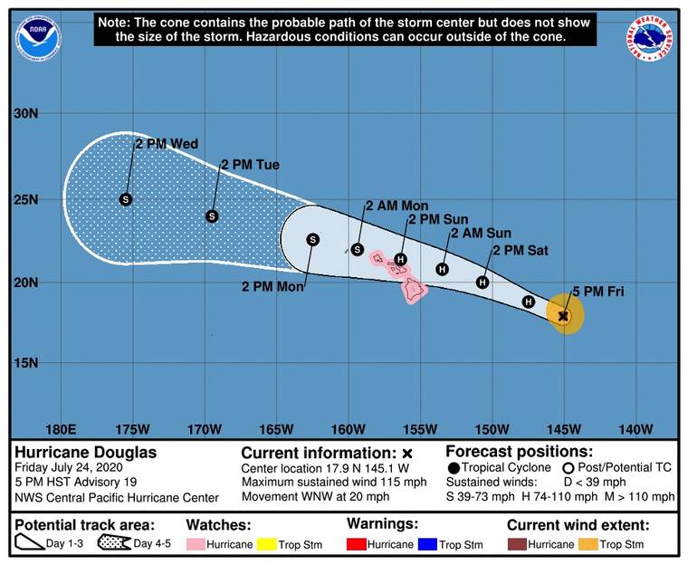
Hurricane Douglas is still expected to strike the state at “near-hurricane strength” on Sunday, according to the National Weather Service.
As of early this evening, the storm was a Category 3 Hurricane about 665 miles east of Hilo, generating sustained winds as high as 115 miles per hour, and moving west at about 20 mph.
Chris Brenchley, meteorologist in charge at the National Weather Service’s Central Pacific Hurricane Center, said the storm is predicted to gradually weaken as it approaches the islands, but will likely still be at or near the strength of a full-fledged hurricane by the time it makes landfall.
Brenchley said the hurricane is projected to deposit up to 15 inches of rain, which he warned can cause life-threatening flash floods and landslides.
Flash flood watches are in effect for the entire state, while the windward-facing shores of most of the islands also are under high surf warnings.
Earlier today, the National Weather Service issued hurricane watches for every county save Kauai. However, the projected path of the storm now tracks somewhat north of the Big Island, with the edges of the storm no longer predicted to pass further south than North Kohala and Hamakua, although the entire island will still receive high winds and rainfall.
According to a 5 p.m. update from the NWS’s hurricane watch, Hilo is expected to receive peak winds ranging between 10-20 mph, with gusts up to 30 mph. However, the watch warns that there remains potential for winds of up to 57 mph, and residents are urged to protect their property in preparation for “limited wind damage.”
Brenchley also warned of the potential for deadly storm surges along the coasts, up to 2 feet above ground in surge-prone areas in East Hawaii.
The National Weather Service urges residents to not attempt to cross flooded roads and to remain vigilant for flood watches and warnings.


