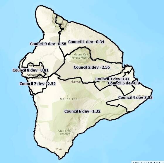
Residents attending public hearings in Kona and Hilo this past week were pretty clear: They didn’t want the Kailua Village business district to be split between County Council districts, nor Waimea, nor Hawaiian Paradise Park, nor the Keaukaha and Panaewa Hawaiian Home Lands property.
The county Redistricting Commission did its best to honor those requests at a meeting Friday, but, after more than four hours of tinkering, were able to accomplish only one of those: it put both Keaukaha and Panaewa back together in Council District 3.
The commission decided to pick the map back up at a meeting Tuesday before finalizing it and submitting its report describing how it came to the boundaries. The new draft map was not available on the county or state mapping websites by press-time Saturday.
“Looking at the map and what we propose, it really validates my previous thoughts about change being hard for people,” said Commissioner James Hustace.
The goal is to create districts of approximately the same size, so everyone gets equal representation in government. Ideal districts follow permanent and easily recognized features like rivers and roads, are compact and contiguous and don’t split neighborhoods of similar interest.
Two West Hawaii commissioners, along with former County Councilwoman Brenda Ford, worried about the lines that divide Kailua-Kona’s business district between Council Districts 7 and 8.
“Kailua Village in my opinion does not need to be cut in half,” Ford said.
Commissioner Stephen Lopez said he tried to protect the urban core in North Kona district 8.
“I didn’t want District 8 to be a bedroom community,” Lopez said.”It’s taking the heart of Kailua-Kona out and making this a bedroom community.”
Based on the new census data, the ideal council district will include 22,232 people. Districts shouldn’t deviate more than 10% above or below that ideal, nor should the difference between the most populated and least populated. Currently the difference between most and least populated stands at 19.38%.
A decade ago, the commission created two districts for fast-growing Puna, cutting one of Hilo’s three districts to accommodate the change, and it significantly changed West Hawaii’s political landscape by creating a Ka’u/South Kona district, a Kona district, North Kona District and Kohala District.
The commission doesn’t have long to do its work because the U.S. Census Bureau was late providing data due to challenges related to the coronavirus pandemic. Maps are due by Dec. 31, according to the county charter. The new districts will be used by candidates who can start qualifying for election starting March 1.
Email Nancy Cook Lauer at ncook-lauer@westhawaiitoday.com.


