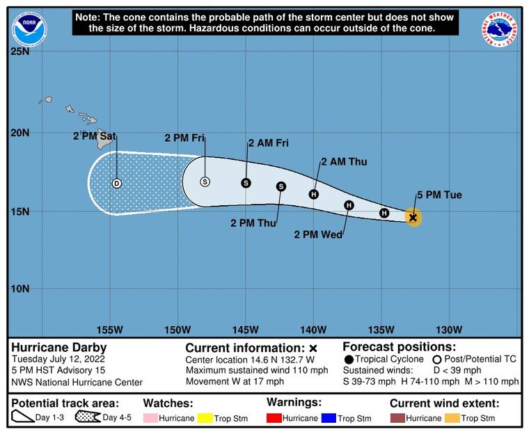
Darby weakens as it moves westward
At 5 p.m. tonight, Hurricane Darby was about 1,520 miles east of Hilo, according to the National Hurricane Center in Miami.
The storm had weakened from a Category-4 storm to a Category-2 storm, with maximum sustained winds of 110 mph.
ADVERTISING
“Darby is on a weakening trend as it continues to move westward,” Leigh Anne Eaton, a forecaster for the National Weather Service in Honolulu said. “It’s expected to cross into our Central Pacific basin at the 140 West (longitude) line sometime Wednesday night or Thursday morning. … But it is expected to continue this weakening trend as it continues to move west.
“We’re not really expecting any direct impacts from it. … Whatever’s left of it as it passes south of the Big Island, you know, enhanced rainfall … and a potential for a little bump up in that east side surf, especially for Hilo, the east-facing shores of the Big Island. So maybe sometime this weekend, the eastern shore surf may be reaching an advisory level.”
Additional weakening is forecast, but Darby is expected to remain a hurricane through Wednesday night and a tropical storm through Thursday night. The system is forecast to become a post-tropical cyclone by late Friday.
Darby remains a small hurricane. Hurricane-force winds extend outward up to 10 miles from the storm’s center and tropical-storm-force winds extend outward up to 45 miles.


