Crater filling at Kilauea is sometimes like pouring liquid into a mug, but more often it is like injecting haupia crème into a crispy malasada.
Since December 2020, two eruptions have been filling the deep pit crater left by the 2018 subsidence of Kilauea caldera. The first eruption started in late December 2020 and lasted 5 months. The second eruption continues and reached one year old on Thursday. As of this week, more than 150 million cubic meters (over 39 billion gallons) of new lava have filled that pit and lifted its floor almost 370 meters (1,200 feet) higher than the deepest point of 2018 subsidence.
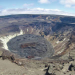
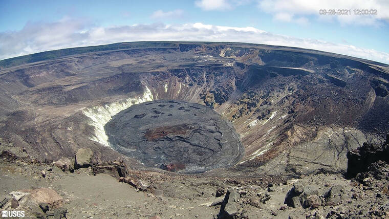
The first eruption started on Dec. 20, 2020, and by the new year, the lava level had risen more than 180 meters (590 feet). The last activity was observed on May 23, 2021, after lava had filled 225 meters (739 feet) of the pit. The crusted crater floor had an area of 45 hectares (111 acres) capping a volume of 41 million cubic meters (over 10 billion gallons) of mostly molten lava. The crater floor was adorned with a main island (formed in the first hours of the 2020-21 eruption), several smaller islands to the east, and a small vent cone at its west edge. The high point of the island was about 25 meters (82 feet) above the surrounding crater floor.
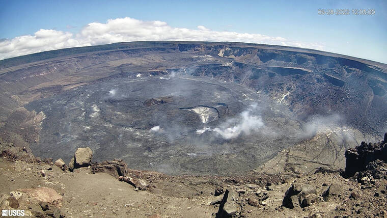
Activity picked up again on Sept. 29, 2021, from a new western cone and from the edges of the crater floor. As of Sept. 12, the 2021-22 eruption has added 111 million cubic meters (29.3 billion gallons) of lava, raised the crater floor another 140 meters (460 feet), and more-than-doubled the area of the 2020-21 crater floor.
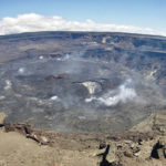
Current views of Halema‘uma‘u show a central oval-shaped plate of 2020-21 crust with its main island frozen into it. While the 2020-21 crater floor is being lifted, new floor is being added around its edges by the 2021-22 ongoing eruption. The erupting vent, called the west cone, seems to be frozen in the same position at the west edge of the 2020-21 crater floor. Currently, the small lava lake occupies less than 1 percent of the crater floor.
The crater floor continues to rise, with a few brief drops, like the top of a piston with the crust mostly intact at its top. Because the pit is shaped like a funnel, the uplifted crater floor must get larger as it moves upward.
While it may seem odd that more lava is not erupted over the crater floor to build it higher flow by flow, history shows us that this piston-like uplift from beneath the floor is a common mechanism by which Kilauea fills its craters. Rev. Titus Coan recognized this in the 1800s when the central part of the caldera floor rose almost 60 meters (197 feet) between two of his semiannual visits. He deduced that it was uplifted from beneath because plants were undisturbed on the raised plateau.
Thomas Jaggar, founder of the Hawaiian Volcano Observatory, observed this process several times between 1916 and 1924. The crater floor would uplift at long-term rates of 0.5-1.5 meters (1.5-5 feet)/day over several months with the faster rates at the start of the uplift.
The 2020-21 and 2021-22 crater floors rose at similar rates. Daily rise rates were higher at the beginning of both recent eruptions but it’s too soon to tell whether the rates are constant or slowing.
On occasion, the 2021-22 eruption lava has covered substantial portions of the crater floor with new lava. The highest parts of the 2020-21 main island are still visible, but the island has been surrounded by about 10 meters (33 feet) of surface flows. Meanwhile, the crater floor was uplifted an additional 130 meters (427 feet) by lava beneath the crust. In other words, most of the molten lava added to Halema‘uma‘u pit crater has not been seen by observers on the surface. Only a small fraction of it trickles out occasionally covering part of the crater floor.
Our malasada analogy breaks down when one considers what would happen if a malasada were injected with filling for more than a few seconds! The Halema‘uma‘u crater floor will continue to rise with continued injection of lava but, sadly, the malasada would burst and become a puddle of pudding. But it would still be a good companion to your morning beverage.
Volcano
activity updates
Kilauea volcano is erupting. Its USGS Volcano Alert level is at WATCH (https://www.usgs.gov/natural-hazards/volcano-hazards/about-alert-levels). Kilauea updates are issued daily.
Over the past week, lava has continued to erupt from the western vent within Halema‘uma‘u crater in Hawai‘i Volcanoes National Park. Sulfur dioxide emission rates remain elevated and were last measured at approximately 970 tonnes per day (t/d) on September 28. Seismicity is elevated but stable, with few earthquakes and ongoing volcanic tremor. Over the past week, summit tiltmeters recorded several minor deflation-inflation (DI) events. For more information on the current eruption of Kilauea, see https://www.usgs.gov/volcanoes/Kilauea/recent-eruption.
Mauna Loa is not erupting and remains at Volcano Alert Level ADVISORY. This alert level does not mean that an eruption is imminent or that progression to an eruption from the current level of unrest is certain. Mauna Loa updates are issued weekly.
This past week, over 400 small-magnitude earthquakes were recorded below the summit and upper elevation flanks of Mauna Loa — the majority of these occurred at shallow depths less than 15 kilometers (9 miles) below sea level. Global Positioning System measurements show low rates of ground deformation over the past week. This increase in seismicity does not mean that an eruption is imminent nor that progression to an eruption is certain. Gas concentrations and fumarole temperatures at both the summit and at Sulphur Cone on the Southwest Rift Zone have remained stable over the past week. Webcams show no changes to the landscape. For more information on current monitoring of Mauna Loa, see: https://www.usgs.gov/volcanoes/mauna-loa/monitoring.
Five earthquakes were reported felt in the Hawaiian Islands during the past week: a M2.3 earthquake 11 km (6 mi) ENE of Pahala at 32 km (19 mi) depth on Sept. 27 at 12:55 p.m. HST, a M4.5 earthquake 9 km (5 mi) ENE of Pahala at 32 km (19 mi) depth on Sept. 27 at 12:43 p.m. HST, a M2.0 earthquake 10 km (6 mi) ENE of Pahala at 29 km (18 mi) depth on Sept. 25 at 7:39 a.m. HST, a M3.5 earthquake 10 km (6 mi) ENE of Pahala at 31 km (19 mi) depth on Sept. 23 at 8:43 p.m. HST, a M2.9 earthquake 2 km (1 mi) NNE of Kahaluu-Keauhou at 18 km (11 mi) depth on Sept. 22 at 6:00 a.m. HST.
HVO continues to closely monitor Kilauea’s ongoing eruption and Mauna Loa for any signs of increased activity.
Email questions to askHVO@usgs.gov.


