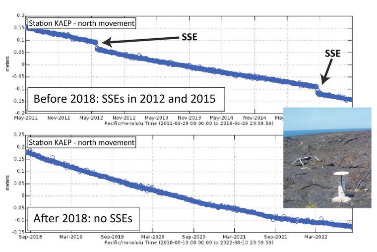
Over the past two decades, both scientists and members of the public have anticipated the occurrence of slow slip events (SSEs) on Kilauea’s south flank. These events are recorded by the Hawaiian Volcano Observatory’s continuous GPS network, which show as much as 2 cm (0.75 inches) of increased seaward motion of the flank over 2-3 days — equivalent to about an M6 earthquake.
South flank SSEs occur on the nearly-flat decollement fault that sits 6-8 km (4-5 miles) below the ground surface at the interface of Kilauea and the preexisting ocean floor. The decollement fault can slip in large earthquakes, as well as via steady creep. “Steady creep” means that portions of the decollement fault are continuously sliding very slowly.
Because of their slow speed, SSEs do not generate the seismic waves that cause hazardous shaking. Thus, both steady creep and SSEs safely release stress.
After 2005, SSEs on Kilauea’s south flank occurred every 2.5 years, give or take 3 months. These included SSEs in June 2007, February 2010, May 2012, and October 2015. HVO anticipated that another SSE would happen between February and August of 2018.
Instead, the lower East Rift Zone eruption of Kilauea began on May 3, 2018. If a slow slip event had occurred during this eruption, the unique spatial and temporal pattern in the continuous GPS would have still been detectable. However, no SSE occurred.
Furthermore, there has not been another SSE on Kilauea’s decollement fault since 2018. It has now been just over seven years since the last one occurred in 2015.
One reason for this may be the M6.9 earthquake that occurred on May 4, 2018, just after the first lower East Rift Zone eruptive vent opening.
The variety of slip behaviors (earthquakes, creep, SSEs) on the decollement fault suggests that the fault has zones with different frictional properties. Some areas have “velocity-weakening” frictional properties, which allows them to initiate (nucleate) earthquakes, and some areas have “velocity-strengthening” friction, which leads to steady creep. Slow slip events can occur in “velocity-strengthening” regions, but can also be an indication that the frictional properties of the fault are more complicated.
“Velocity-weakening” frictional properties are something most of us a familiar with. If you’re trying to move a heavy box, you just need to get the box sliding a little bit before it moves easily. This is because the strength of the frictional force between the box and floor goes down once it starts sliding.
Earthquakes occur as quickly as they do because once the stress on the fault is high enough to slide it a little (nucleate), it becomes easier to continue slipping until the excess stress is used.
“Velocity-strengthening” friction is less intuitive; its more similar to “drag” processes.
If you have ever tried to quickly wade through knee-deep water, then you may remember that it gets harder, the faster you try to move. The best strategy is to choose a slow even pace, one that matches the drag force of the water to your strength.
In the same way, faults with velocity-strengthening friction must release their stress slowly and evenly, balancing the frictional force that increases as they slide, to the driving stress.
So why would the M6.9 earthquake prevent SSEs from occurring? Although earthquakes can’t nucleate in velocity-strengthening regions, if an earthquake starts with enough energy, it can grow into an SSE region.
The effect is somewhat like running from shore into the ocean; you might get far if you start with enough speed. This is what the 2018 M6.9 earthquake did; its epicenter was offshore and west of Kalapana, but the earthquake involved slip on a 26 km (16 mile) length of the fault, stretching to the west and including the region of the decollement fault that produced SSEs.
The massive stress release of the earthquake rupture means that the section of the fault that produced SSEs may need time before it has built enough stress to start producing SSEs again.
Observing what happens next and what (if anything) brings the SSEs back, could provide a fascinating view into the frictional properties of Kilauea’s south flank decollement fault. The massive changes that the 2018 eruption brought to the landscape and to Kilauea, will continue to drive interesting science for years to come.
Volcano
activity updates
Kilauea is erupting. Its USGS Volcano Alert level is at WATCH. Kilauea updates are issued daily.
Kilauea volcano’s summit eruption in Halema‘uma‘u crater within Hawai‘i Volcanoes National Park continues, at decreased levels since February 20.
Summit tilt has shown several deflation-inflation events over the past week. Summit earthquake activity remains low and eruptive tremor (a signal associated with fluid movement) is present. A sulfur dioxide emission rate of 2,000 tonnes per day was measured on February 13.
For Kilauea monitoring data, see https://www.usgs.gov/volcanoes/Kilauea/past-week-monitoring-data-Kilauea.
Mauna Loa is not erupting. Its USGS Volcano Alert Level is at ADVISORY. Mauna Loa updates are issued weekly on Thursdays.
Webcams show no signs of activity on Mauna Loa. Seismicity remains low.
Deformation rates show inflation somewhat above background levels, but this is not uncommon following eruptions. Sulfur dioxide (SO2) emission rates are at background levels.
For Mauna Loa monitoring data, see: https://www.usgs.gov/volcanoes/mauna-loa/monitoring-data.
There were two earthquakes with 3 or more felt reports in the Hawaiian Islands during the past week: a M2.9 earthquake 10 km (6 mi) ENE of Pahala at 31 km (19 mi) depth on Feb. 17 at 4:26 p.m. HST and a M2.6 earthquake 10 km (6 mi) NE of Pahala at 31 km (19 mi) depth on Feb. 16 at 4:28 p.m. HST.
HVO continues to closely monitor the ongoing eruption at Kilauea, and Mauna Loa.
Please visit HVO’s website for past Volcano Watch articles, Kilauea and Mauna Loa updates, volcano photos, maps, recent earthquake info, and more. Email questions to askHVO@usgs.gov.
Volcano Watch is a weekly article and activity update written by U.S. Geological Survey Hawaiian Volcano Observatory scientists and affiliates.


