UPDATE: Calvin maintains strength as it nears Big Island
UPDATED 5:35 p.m.
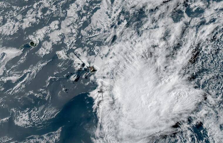
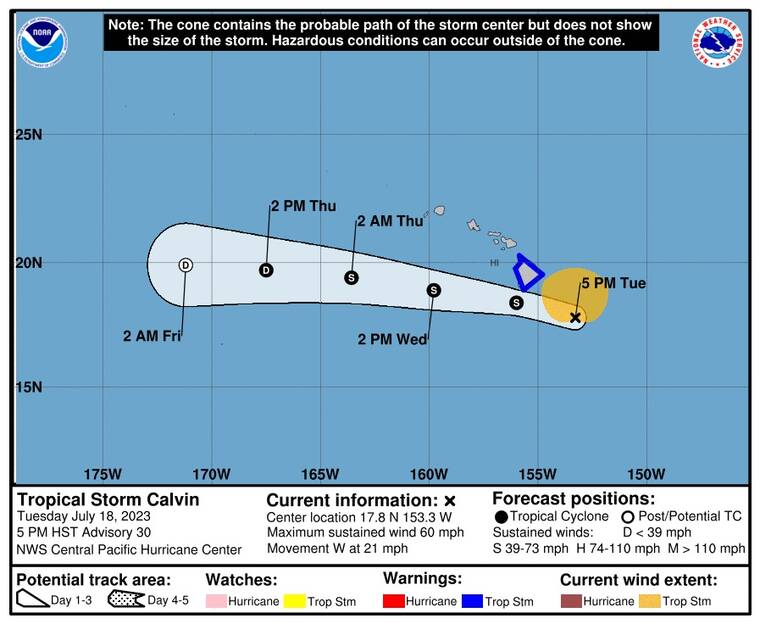
Tropical Storm Calvin has maintained its strength as it advances toward the Big Island.
ADVERTISING
Calvin brings maximum sustained winds of 60 mph, with possible higher gusts, and was moving west at 21 mph.
The storm at 5 p.m. was less than 200 miles southeast of Hilo.
A tropical storm warning has been issued for all of Hawaii County. A tropical storm warning is issued when tropical storm force winds of 39 mph to 73 mph are expected within the next 36 hours.
UPDATED 2:15 p.m.
All 14 state parks on Hawaii Island will close at 4 p.m. today and will remain closed Wednesday in anticipation of Tropical Storm Calvin, according to the state Department of Land and Natural Resources.
State parks will reopen following assessments of any damage.
UPDATED 1:40 p.m.
State offices in Hawaii County will be closed Wednesday due to expected severe weather conditions caused by Tropical Storm Calvin, according to a press release from Gov. Josh Green’s office.
This will allow for employees to take precautions and safety actions as they prepare for and respond to the effects of the storm, which is expected to impact the state beginning this evening.
Nonessential employees affected by the closing of those offices should not report to work and shall be granted administrative leave except for “departmental disaster/emergency coordinators, disaster response workers, and employees whose work involves continuing crucial operations/services, such as hospital workers, correctional workers, etc.”
Employees who fall into one of the above categories are required to report to work to ensure essential operations continue throughout the county.
In anticipation of Calvin, Green also has signed an emergency proclamation to make resources available to address potential storm impacts.
The closure includes all Big Island courts, according to a statement from the Judiciary.
UPDATED 11:30 a.m.
Tropical Storm Calvin has strengthened slightly as it continues to approach Hawaii Island.
At 11 a.m. today, the storm was 245 miles east-southeast of Hilo, packing maximum sustained winds of 50 mph, with higher gusts.
The storm continues to move westward at a brisk 22 mph clip, and a tropical storm warning remains in effect for Hawaii County.
The county issued a statement today, saying Department of Public Works, Building and Engineering divisions will not conduct any permit or project inspections on Wednesday.
In the interest of public safety, the county is closing all county parks at 4 p.m. today. They will remain closed through Wednesday.
In addition, the county has prepared additional emergency shelters to accommodate those needing refuge during the storm. The following locations will open today at 2 p.m. to provide safe shelter: Pahoa High School, Hilo High School, Keaau Armory, Robert Herkes Gymnasium in Pahala, Naalehu Community Center, Honokaa High School, Hisaoka Gymnasium in Kohala and Waimea Elementary School.
These shelters are pet-friendly, and pet owners must bring carriers and necessary animal supplies.
PREVIOUSLY
Tropical Storm Calvin continues to move quickly and steadily toward the Big Island.
A tropical storm warning remains in effect for Hawaii County. A tropical storm warning means means that tropical storm conditions are expected somewhere within the warning area, in this case within the next 12 to 24 hours.
At 8 a.m., the storm was about 330 miles southeast of Hilo, packing maximum sustained winds of 45 mph with locally higher guests. Tropical-storm-force winds extend outward up to 105 miles from the center.
On the forecast track, tropical storm conditions will likely begin spreading over Hawaii County starting this evening.
Winds around Calvin are expected to be generally the same through today, then are expected to gradually weaken from tonight through Thursday.
Persons in Hawaii County should complete preparations for tropical storm force wind impacts today during daylight hours prior to the onset of tropical storm conditions tonight.
From later today into Thursday, storm total rainfall amounts of 4 to 8 inches, with maximum amounts of 10 inches are possible, mainly along the windward areas of the Big Island of Hawaii.
Storm total rainfall amounts of 3 to 6 inches are expected elsewhere in the state.
This rainfall could lead to localized flash flooding and mudslides.
Surf swells generated by Calvin are expected to begin spreading across the main Hawaiian Islands later today and tonight.
This will lead to a rapid increase in surf along east facing shores, with high surf continuing into Wednesday. This elevated surf will likely cause life-threatening conditions along exposed shorelines.
Big Island residents and visitors are advised to continue monitoring official sources of information.


Get the Latest News
Most Popular
