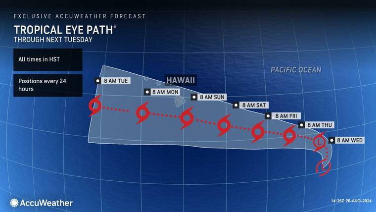
Forecasters are keeping an eye on a pair of weather disturbances over the western portion of the East Pacific basin, about 1,350 miles east-southeast of Hilo.
The disturbances, which have created a large area of disorganized showers and thunderstorms, were expected to have merged overnight, and gradual development is anticipated after that merger. A tropical depression is expected to form today or Thursday and move gradually westward at 10 to 15 mph, according to forecasters.
The system is expected to move into the Central Pacific basin late this week, strengthening as it approaches Hawaii late this weekend or early next week.
A projected track developed by meteorologists working for AccuWeather, a commercial weather forecasting service, has the eye of the storm passing south of the islands. While it’s too early to determine the exact location and magnitude of potential impacts as the system approaches, Hawaii residents should monitor this disturbance.
Meteorologists for AccuWeather say that the storm’s passing could be a double-edged storm — and what they’re saying is colored by the experience of Aug. 8, 2023, when red-flag level high winds of 60 mph and more generated by Hurricane Dora led to wildfires that leveled most of Lahaina, killed more than 100 people on Maui, and damaged or destroyed seven buildings in West Hawaii.
“A majority of the Hawaiian Islands have experienced worsening drought conditions in recent weeks, so any rainfall will be beneficial to the island chain,” said AccuWeather Meteorologist Brandon Buckingham. “However, if a majority of the rain strays to the south of the islands and the primary impacts from the storm come from gusty winds, the wildfire risk could greatly increase as the storm passes by.”
While this storm might not develop into a Category 4 Hurricane like Dora, any tropical cyclone passing nearby can affect the islands.
“Even a less-intense tropical storm or depression that moves directly toward the islands will raise some dry winds in advance of moisture and showers and thunderstorms,” said Brett Anderson, AccuWeather senior meteorologist and climatologist. “Then once the feature’s moisture overspreads the islands, the risk of wildfires would diminish due to the wet landscape, regardless of wind intensity.”
Alex DaSilva, AccuWeather’s lead hurricane expert, said the stronger the storm, the worse the consequences of winds that don’t produce rain during a drought.
“In terms of kicking up strong dry winds that can enhance the wildfire risk, a fully developed tropical storm or hurricane passing just to the south of the islands but not bringing rain would be a worst-case scenario,” he said.
In addition, forecasters are also keeping track of Tropical Storm Gilma, which, as of Tuesday, was about 890 miles southwest of the southern tip of the Baja California peninsula in Mexico.
Still more than a week away from Hawaii, Gilma, as of Tuesday, was moving to the west-northwest at about 12 mph, packing maximum sustained winds near 70 mph. The storm is forecast to strengthen steadily, and Gilma is expected to become a hurricane today.
Email John Burnett at jburnett@hawaiitribune-herald.com.


