Forecasters: Be ready for wind, rain, surf this weekend


Weather watchers continue to keep track of a couple of potential trouble spots for Hawaii — including one that is now a hurricane.
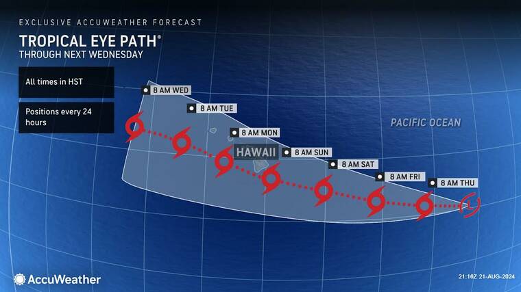
An area of disturbance just east of the Central Pacific basin hadn’t yet developed into a tropical depression or storm as of late Wednesday afternoon, but exhibited the potential to do so either Wednesday night or sometime today. If it develops into a tropical storm after crossing the 140-degree West longitude marker into the Central Pacific, it would be given the name Hone, which ironically means “sweet and soft” in Hawaiian. If it develops prior to crossing the Central Pacific meridian, the storm will be named Hector.
ADVERTISING
Either way, the low-pressure area of showers and thunderstorms continues to move in a generally westward direction at 10 to 15 mph. The system is expected to strengthen as it approaches Hawaii either late this weekend or early next week.
AccuWeather meteorologists have begun to refer to this potential threat as a tropical wind and rainstorm to raise public awareness of the potentially serious nature of the system. AccuWeather is forecasting the system to strengthen into a named tropical storm within the next 24 to 48 hours.
“An area of high pressure is north of Hawaii right now. Trade winds are blowing in from the east-northeast,” said Bernie Rayno, AccuWeather chief on-air meteorologist. “The upper high is going to produce a southeasterly steering flow, which will steer this tropical threat toward Hawaii as we approach the weekend.”
“That’s our biggest concern right now,” added Alan Reppert, AccuWeather senior meteorologist, on Wednesday. “We are expecting this to develop in the next day. And we’re looking at Sunday into Monday for the worst conditions from this.
“It looks to be a tropical storm as it pushes into the area. It’s going to be south of the Big Island, so it won’t be making a direct hit, which is pretty rare. But we are expecting some rain with that — the heaviest rain on the windward sides of the mountains there. And we are expecting some stronger wind gusts on the leeward side, which could be a dangerous situation.”
AccuWeather meteorologists are forecasting 1-2 inches of rain across the islands with 2-4 inches across the Big Island and Maui. Rainfall totals could span from 4-8 inches across the windward side of the Big Island, with a chance of flash flooding.
Rough surf and gusty winds are also possible across portions of the islands this weekend as the storm approaches from the east. Wind gusts of 40-60 mph will be possible across the Big Island with locally higher gusts of 60-80 mph possible across the higher terrain.
According to Rayno, cooler waters south of the islands could prevent this tropical threat from gaining additional wind intensity.
“The water temperatures are a bit lower than the historical average just south of Hawaii,” he said. “That could help prevent this storm from intensifying into a hurricane.”
Last August, Hurricane Dora, a category-4 hurricane, passed well south of the islands while strong high pressure hovered to the north. The combined circulation of both systems created stiff east-northeast winds that downed trees and power lines and triggered rapidly spreading and deadly wildfires, causing more than 100 deaths on Maui and claiming seven structures in West Hawaii.
AccuWeather meteorologists do not expect the winds to be as strong as they were during the event last August, which led to the Lahaina wildfire.
And while the most immediate concern is the yet-to-be named disturbance about to enter the Central Pacific neighborhood, forecasters are also keeping an eye on more trouble brewing in the Eastern Pacific.
Hurricane Gilma is now a category-2 hurricane. As of 5 p.m. Wednesday, Gilma was at 2,060 miles east of Hilo, packing maximum sustained winds of 110 mph and moving to the west-northwest at 7 mph.
Gilma, the seventh named storm in the Eastern Pacific this hurricane season “looks like it could factor into things,” according to Reppert.
“It is still very far out, so it’s really difficult to tell whether it will be a factor for Hawaii,” he said. “It will be strengthening here in the next day or two until it hits some cooler waters and more unsettled conditions. Once it hits that, it will start to lose wind intensity.
“But any effects from Gilma look to be well into the future, probably in seven to eight days. But by then, it should be much weaker than it currently is. It does look like it’s going to go north of the islands, and if so, that should be a good thing, because the winds should be in the tropical storm range or even less, at that point.”
In addition, disorganized showers and thunderstorms continue in association with a low pressure trough centered several hundred miles southwest of the coast of southwestern Mexico.
According to forecasters, a tropical depression is likely to form in the next two to three days while the system moves west-northwestward into the central portion of the Eastern Pacific.
Email John Burnett at jburnett@hawaiitribune-herald.com.
