Volcano Watch: Volcanic tremor or distant earthquake? Distinguishing seismic signals
The island of Hawaii is one of the most seismically active areas in the world, producing thousands of earthquakes every year. It also commonly produces a signal called tremor that can originate from the volcanic system.
Tremor is characterized by slowly emerging seismic waves which may last for minutes to many days when there are ongoing eruptions. It is important to identify tremor because this signal can be associated with fluid movement, which can sometimes indicate an increased chance of eruption. However, tremor is often difficult to locate because the waves slowly emerge from the background noise and can persist for minutes to weeks or even years — shallow tremor at Kilauea or Mauna Loa is often directly associated with ongoing eruptive activity.
ADVERTISING
In contrast, earthquakes usually have sharp onsets which are easy to see. The time that an earthquake signal appears at the many stations that make up the USGS Hawaiian Volcano Observatory (HVO) seismic network can be used to find the earthquake’s location. Instead, the location for tremor bursts is often estimated by looking at the signal size (or seismic amplitude) at multiple seismic stations and then determining the approximate position and depth.
As an example, shallow tremor bursts at Mauna Loa summit might have strong seismic amplitudes at stations near the summit of Mauna Loa, but very weak signals by the time the signal arrives at the Kilauea seismic stations. By contrast, a tremor burst deep below Pahala may have almost the same seismic amplitudes on several stations near Pahala, and only to become weak at seismic stations in Kona, or Hilo.
It is important to note that not all tremor-like signals are related to volcanic activity and in some cases may not be from the island of Hawaii. A large magnitude-7.4 earthquake deep beneath Chile on July 19 at 3:50 p.m. HST produced strong ground shaking in Chile and was also recorded on the HVO seismic network.
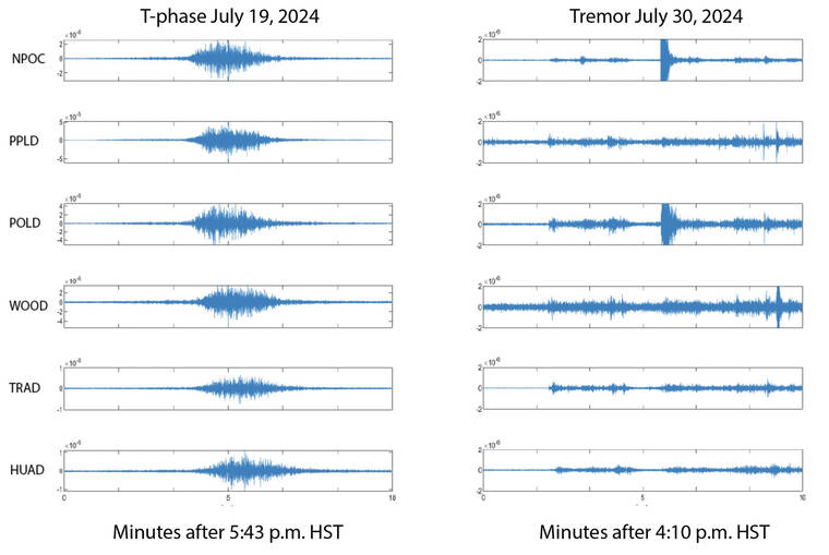
This earthquake also produced a strong hydroacoustic signal (a sound wave traveling through water) — called the T-phase — which was recorded throughout the Pacific basin. T-phases are very different from a tsunami wave and are not hazardous to people. They move at a speed of almost 1.5 kilometers per second (about 3,355 mph) and so would take just under 2 hours to get from Chile to the state of Hawaii.
In this case the wave is transmitted through the ocean predominantly within a horizontal layer called the Sound Fixing and Ranging (SOFAR) channel, which tends to efficiently trap or guide hydroacoustic sound waves. When the T-phase reaches the coast in the state of Hawaii, its energy is converted back into a seismic signal that looks remarkably like local volcanic tremor on the HVO seismic network.
Because HVO is always vigilantly monitoring seismic signals, HVO scientists often need to distinguish between local volcanic tremor and the T-phase from a distant earthquake. The figure here shows an example of local tremor burst deep beneath Pahala at 4:13 p.m. HST on July 30. By comparing this local tremor burst to the earlier T-phase event from Chile on July 19, we see that the T-phase event has arrivals that are spread out in time across the HVO seismic network — a result of the slower speed of the acoustic waves in the water. By contrast, the deep volcanic tremor beneath Pahala arrives at the different HVO stations at about the same time — a result of the local source and faster wave speeds found for basaltic rocks.
HVO scientists can distinguish local tremors from distant earthquakes by assessing arrival times for signals and evaluating their amplitudes. They can further confirm that the observed signal is a T-phase by looking for large events in the global earthquake catalog. This seismic sleuthing is one of the many facets of volcano monitoring in Hawaii.
Volcano activity updates
Kilauea is not erupting. Its USGS Volcano Alert level is ADVISORY.
Seismic activity and ground deformation continues at Kilauea’s summit and upper-to-middle East Rift Zone, with another intrusive event near Pauahi Crater from August 19-20. Over the past week, about 800 earthquakes were detected beneath Kilauea’s upper East Rift Zone and about 100 events were detected between Maunaulu and Pu‘u‘o‘o in the middle portion of the East Rift Zone within Hawaii Volcanoes National Park. Over the past week, Kilauea’s summit and middle East Rift Zone showed slow inflation, followed by slow deflation during the intrusive event. Since then, there has been relatively little ground deformation recorded in these regions. Unrest may continue to wax and wane with changes to the input of magma in these areas; changes can occur quickly, as can the potential for eruption.
Mauna Loa is not erupting. Its USGS Volcano Alert Level is at NORMAL.
Fourteen earthquakes were reported felt in the Hawaiian Islands during the past week; only those above magnitude-3 are listed below: a M4.7 earthquake 15 km (9 mi) S of Fern Forest at 6 km (4 mi) depth on August 22 at 12:52 a.m. HST, a M3.4 earthquake 6 km (3 mi) S of Volcano at 0 km (0 mi) depth on August 20 at 9:22 a.m. HST, a M3.2 earthquake 8 km (4 mi) S of Volcano at 0 km (0 mi) depth on August 20 at 7:22 a.m. HST, a M3.8 earthquake 11 km (6 mi) NE of Pahala at 31 km (19 mi) depth on August 20 at 5:32 a.m. HST, a M3.9 earthquake 30 km (18 mi) WNW of Hawaiian Ocean View at 11 km (7 mi) depth on August 20 at 3:52 a.m. HST, and a M3.2 earthquake 6 km (3 mi) S of Volcano at 1 km (0 mi) depth on August 20 at 2:46 a.m. HST. HVO continues to closely monitor Kilauea and Mauna Loa.


