Lava claims hundreds of Kapoho-area homes; destruction assessments continue


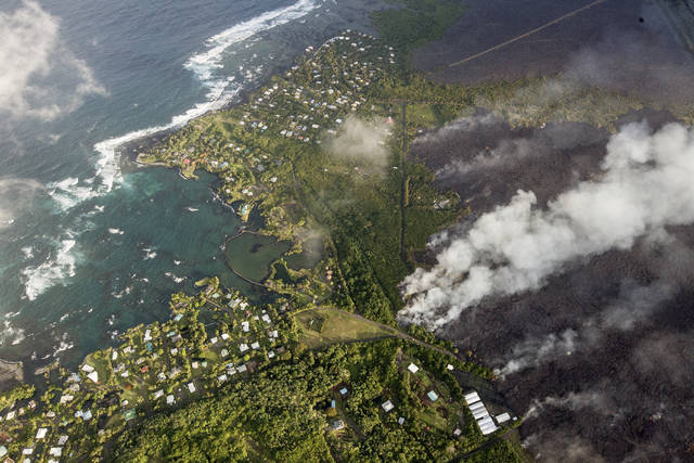
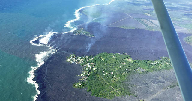
County agencies continued their assessments Tuesday of the destruction around Kapoho after most of Kapoho Beach Lots and Vacationland were buried by lava Monday night.
County agencies continued their assessments Tuesday of the destruction around Kapoho after most of Kapoho Beach Lots and Vacationland were buried by lava Monday night.
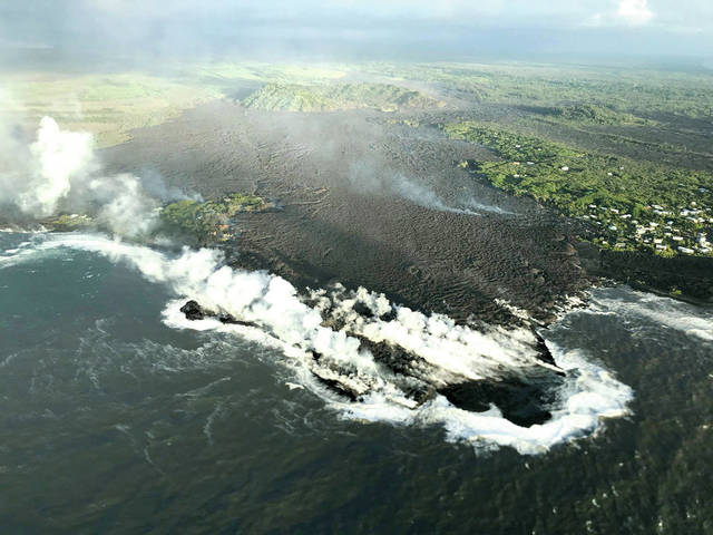
A wide and fast lava flow from Kilauea volcano’s fissure No. 8 wiped out hundreds of homes in Kapoho and obliterated Kapoho Bay, replacing it with a nearly mile-long delta of lava rock.
ADVERTISING
Hawaii County Civil Defense Administrator Talmadge Magno said the official count of destroyed homes since May 3 has not risen from the tally of 117 announced earlier this week. However, it was clear Monday that the vast majority of the approximately 500 homes in Kapoho Beach Lots and Vacationland are gone.
A small cluster of homes at the north end of Kapoho remains standing, while a stretch of homes along the Vacationland coast is likewise unharmed. The rest of the homes, however, are burned and buried.
It was confirmed later Tuesday evening following the latest aerial surveillance of the area that a home owned by Mayor Harry Kim in Vacationland was destroyed. County Managing Director Wil Okabe also owns a property in Kapoho, although he said Tuesday afternoon that he could not confirm whether it still stands.
“There’s always miracles, right?” Okabe said. “It could be spared today, but it might be gone tomorrow.”
Okabe lamented the loss of the surrounding community, as well as the destruction of two popular visitor destinations, Champagne Ponds and the Kapoho tide pools, coastal features popular with snorkelers that also were inundated by lava.
“I’m going to remember how it was such a pristine place to get away from the hustle and bustle of the city,” Okabe said. “My kids were able to enjoy it, but my grandson won’t be able to enjoy it in the same way.”
Magno said an estimated 80 percent of homes in the area are some form of vacation rental property. However, evacuees are many, with an estimated 400 at the Red Cross shelters in Pahoa and Keaau, the latter of which is at maximum capacity.
“I’m really kind of at peace, actually,” said Kapoho resident Mark Johnson. “I’ve had 28 years of wonderful experience down there in Kapoho.”
Discussions about future accommodations for evacuees are continuing, Magno said. Sacred Heart Church in Pahoa offered some of its land as a location for temporary dwellings, while other entities made similar offers.
No rescues were made Monday or Tuesday, Magno said. However, he reminded residents to keep in mind the limits of emergency responders.
“We do not do aerial evacuation rescues at night,” Magno said.
Magno also advised residents to not rely on social media to obtain updates about the eruption.
A state Department of Transportation official confirmed Tuesday that two evacuation routes out of lower Puna — to be used if Highway 130 is compromised — have been completed. Chain of Craters Road was cleared of lava last week, while a second route through Sanford’s Service Center and connecting with Alaili Road was completed Tuesday.
A third route will be considered if one of the routes, including Highway 130, is cut off.
Steve Brantley, deputy scientist-in-charge at Hawaiian Volcano Observatory, said the cracks under Highway 130 continue to generate heat, but have not displayed significant widening. He noted the cracks can open quickly and at any time.
Gov. David Ige issued a second emergency proclamation Tuesday, extending the state of emergency until Aug. 4. The proclamation also suspends a number of state laws regarding administrative procedures, health and housing in order to facilitate emergency response actions.
HVO spokeswoman and geologist Janet Babb said fountaining from fissure 8 has lessened somewhat, although she said it is premature to take such a change as a sign that the fissure is weakening.
Similarly, Babb said increased heat and steam emissions observed from fissures 9 and 10, located southwest of fissure 8 in an area of Leilani Estates largely untouched by lava, should not be taken as a sign that those vents are reactivating.
At Kilauea summit, the mountain has been rocked by frequent earthquakes and explosions. A large explosion early Tuesday morning registered on seismometers as a magnitude-5.5 earthquake, although Babb said it was not a standard earthquake.
Because of the plugged volcanic shaft at Halema‘uma‘u crater, the mounting pressure that fuels the explosions is transferred into the earth itself, causing a tremor that appears to be an earthquake in areas close to the explosion. Unlike a conventional earthquake caused by shifting fault lines, these quakes are not felt particularly far from their epicenters, Babb said.
Babb said there is a great deal of discussion as to what is fueling the repeated explosions at the summit. While the initial hypothesis was that the water table infiltrated the empty volcanic shaft and evaporated, building pressure behind a blockage until it explodes, it is now unclear whether the current explosions are caused by a buildup of steam or volcanic gas.
Regardless of the cause, more than 12,000 earthquakes have rocked the summit since the eruption began. Five hundred of the quakes occurred Sunday alone, the most earthquakes ever recorded there in a 24-hour period, Babb said.
Email Michael Brestovansky at mbrestovansky@hawaiitribune-herald.com.


