After the lava flows from the 2018 Kilauea eruption took out more than 700 homes and cost tens of millions of dollars in road reconstruction and land buyouts, the county spent more than $2 million on a consultant to conduct an islandwide volcanic risk assessment as well as a Kilauea recovery plan.
The 400-plus-page volcanic risk assessment by Honolulu-based Tetra Tech Inc. was completed in June 2020. But little, if any, action has been taken on the report, nor do several top administrative officials seem to be familiar with it.
Mayor Mitch Roth, questioned about the report during a Friday press conference updating journalists on the Mauna Loa eruption, asserted there were a “lot of things we’ve done over the last couple of years,” before kicking the question over to Civil Defense Administrator Talmadge Magno.
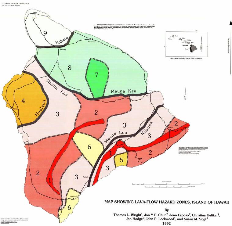
Magno said, “I don’t know any results from this plan,” but added that “in concert with the hazard maps and what we have in place that minimize development just based on regulations … in those critical zones of zone 1 and zone 2 .. it’s already built into the policies.”
But 10% of the county’s volcanic high hazard area land is categorized for urban expansion or as another urban category, such as high-, medium-, or low-density urban, according to the report. The volcanic high hazard area is defined as lava zones 1 and 2, including a 1,000-foot buffer. Historic lava flow areas dating back to 1790, and NEHRP class soils D and E, which amplify and magnify ground shaking and increase building damage and losses, were also included.
Some 10,688 households, 14.7% residents and some $5.2 billion in assets lie within this high hazard zone, which covers 34.1% of land on the island.
Consultants estimate 12.4% of the island population lives in lava zones 1 and 2, and another 59.3% live in lava zone 3.
They noted that most of the land in lava zones 1 and 2 is classified as conservation land, rural and extensive agriculture land, but “there is still land designated for low- and medium density urban uses that will put assets in these areas at risk to volcanic hazard impacts.”
Those areas include Puna as well as a significant portion of South Kona and Ka‘u.
“Future land use decisions and future policy should consider the location of the volcanic and additional natural high hazards prior as part of future development decisions. … Redevelopment or continued development is not always the preferred option,” consultants said in the report. “Future redevelopment and greenfield development should be carefully considered with a full understanding and assessment of the implications of adding new uses and potentially new population in areas of the County with high volcano risk and exposure.”
Among the seven recommendations offered by the consultants is to incorporate the volcanic high hazard area as a hazard overlay in the county’s general plan update to reduce future land use development in high hazard areas and develop regulatory tools and incentives to reallocate existing and potential development to less hazardous areas of the county.
With the county’s general plan update now in the works, it’s possible land planners will brush the dust off the report.
“We are taking a hard look at policies related to lava hazard zones 1 and 2 in the general plan,” Planning Director Zendo Kern said Friday. “The 2018 Kilauea eruption and the current Mauna Loa eruption underscore the need for sound policies and direction in these areas.”
The entire report can be found at https://bit.ly/3UqkYaw.
Email Nancy Cook Lauer at ncook-lauer@westhawaiitoday.com.


