Forecasters keeping eye on Tropical Storm Greg, Hurricane Fernanda


Forecasters with the National Weather Service are keeping a watch on two tropical cyclones moving westward in the Pacific.
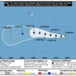
At 8 a.m. this morning, Tropical Storm Greg was about 1,050 miles east-southeast of Hilo.
ADVERTISING
Maximum sustained winds are 50 mph, and the storm is moving west at about 11 mph. That westward movement is expected to continue for the next few days.
Some slight strengthening is possible during the next couple of days. Tropical-storm-force winds extend outward up to 35 miles from the center.
Civil Defense issued a tropical storm information statement this morning about Greg, noting the Central Pacific Hurricane Center forecasts the storm is expected to have no impact on Hawaii Island as it passes south of the island.
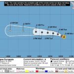
Meanwhile, the National Hurricane Center in Miami is issuing advisories on Hurricane Fernanda, located about 2,400 miles east of Hilo. It is moving west at about 8 mph.
Fernanda, which is still much closer to Mexico than it is to Hawaii, is a category-4 hurricane, packing maximum sustained winds of near 130 mph.
Some additional strengthening could occur today. A weakening trend is expected to begin tonight or early Tuesday.
Hurricane-force winds extend outward up to 25 miles from the center and tropical-storm-force winds extend outward up to 70 miles.
A general west to west-northwest motion is expected to continue with some increase in forward speed over the next few days. Fernanda is expected to cross into the Central Pacific on Friday as a weakening tropical storm.
Hurricane season for the Central Pacific Basin is from June 1 to Nov. 30. Civil Defense advises the public to take this time to review family emergency plans and your emergency kits.
Visit the Civil Defense website at https://hawaiicounty.gov/civil-defense for more information.
Email John Burnett at jburnett@hawaiitribune-herald.com.


