Ignacio became the eighth hurricane to form this year in the east and central Pacific on Wednesday as its path shifted northwest toward the Big Island. ADVERTISING Ignacio became the eighth hurricane to form this year in the east and
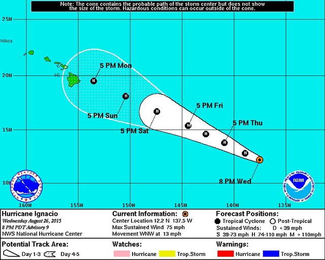
Ignacio became the eighth hurricane to form this year in the east and central Pacific on Wednesday as its path shifted northwest toward the Big Island.
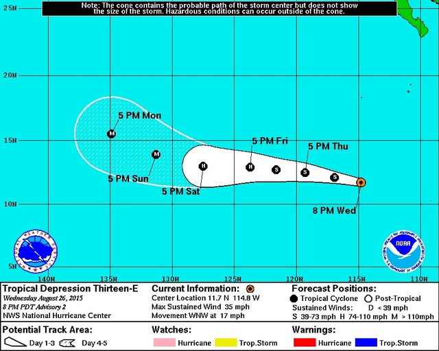
And, if that wasn’t bad enough, a tropical depression that could become a major hurricane by Sunday afternoon has formed behind it. That storm is forecast to follow a similar west-northwest track during the next five days.
It’s not clear how much of a threat that storm might become, and Ignacio remained the immediate concern, with a strong subtropical ridge of high pressure expecting to guide it toward the islands.
As of Wednesday evening, it had maximum sustained winds of 75 mph and was moving west-northwest at 13 mph. As of that afternoon, it was about 1,300 miles east-southeast of Hilo.
Favorable conditions will allow Ignacio to strengthen to a major hurricane by Friday evening, with sustained winds greater than 110 mph. It’s expected to weaken to a category 1 or low-end category 2 hurricane as it nears the island Monday.
Chevy Chevalier, a National Weather Service meteorologist in Honolulu, said isle residents could begin seeing impacts from the hurricane late Sunday or early Monday if it remains within the “cone of uncertainty,” which shows the storm’s most likely paths. The island remained within that large cone as of Wednesday evening.
The forecast track will become more refined during the next couple days, he said.
While other storms have veered away from the island this summer, Chevalier said residents shouldn’t assume Ignacio will do the same.
“If they’re not preparing, they should be preparing right now just in case,” he said.
Sea surface temperatures that are a few degrees above normal and lower wind shear will help Ignacio remain a hurricane as it approaches, forecasters say.
“In previous years, our cooler temperatures really have helped to weaken the storms,” said Leigh Ann Eaton, weather service meteorologist. “With the warmer sea temperatures, we don’t see that being a huge player.”
As for Tropical Depression 13E, the storm behind Ignacio, Eaton said it was impossible to say how much of a threat it could become to the island. It was more than 2,700 miles east of Hilo on Wednesday afternoon.
If its current forecast holds, the storm could be 1,300 miles east of Hilo on Monday as either a category 3 or 4 hurricane, Eaton said.
Email Tom Callis at tcallis@hawaiitribune-herald.com.


