August blew into the Eastern Pacific, literally, with Tropical Storm Howard becoming the eighth named storm of this year’s Pacific hurricane season. ADVERTISING August blew into the Eastern Pacific, literally, with Tropical Storm Howard becoming the eighth named storm of
August blew into the Eastern Pacific, literally, with Tropical Storm Howard becoming the eighth named storm of this year’s Pacific hurricane season.
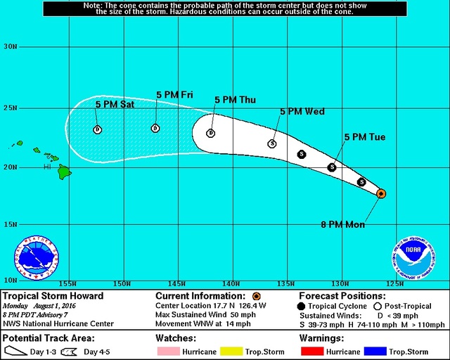
Forecasters are predicting Howard will weaken to a post-tropical remnant low-pressure system before crossing into the Central Pacific on Thursday. Big Island residents will see a significant uptick in rain at about that time, however, because of the remnants of former Hurricane Frank, according to forecaster Jon Jelsema with the National Weather Service in Honolulu.
“We’ll see a marked increase in, especially, windward showers Wednesday night and Thursday,” Jelsema said Monday afternoon. “A lot of the remnants of (former Hurricane) Georgette actually went to the north of the Big Island, so you missed out on a lot of the rainfall that was seen, especially over Oahu and Kauai, in the last day or two. You’re going to see a marked increase in rainfall. It’s going to be a lot different than the typical trade wind showers — heavier showers, and a lot more persistent.”
Some windward Oahu spots saw an unaccustomed amount of rainfall in the 24-hour period ending at 8 a.m. Monday. Punaluu Stream reported 5.51 inches of rain, while the gauge at Kahana measured 4.42 inches. On Kauai, Mount Waialeale, the rainiest spot on Earth, received 4.2 inches and Wainiha measured 4.08 inches.
At 5 p.m. Monday, Howard was about 1,725 miles east of Hilo, traveling to the west-northwest at 14 mph with maximum sustained winds of 50 mph. At that time, the storm was forecast to strengthen to about 60 mph in the next 24 hours and then gradually weaken into a tropical depression with maximum sustained winds of about 35 mph when it crosses into the Central Pacific.
“It’s really coming into an unfavorable environment with a lot of deep-layer vertical wind shear, which really helps to knock the storm apart,” Jelsema said. “It’s also moving into an area of cooler sea-surface temperatures. That’s another unfavorable condition for keeping tropical cyclones together.”
Howard’s remnants are forecast to pass north of the Big Island on Saturday night. And although Howard isn’t expected to have any appreciable effect on Hawaii, former Hurricane Darby, which came ashore on the Big Island as a tropical storm 10 days ago before hammering Oahu with lightning, heavy rain and flooding, was also projected to miss the Islands.
“It’s not something we want to take our eyes off,” Jelsema said. “These systems have a way of doing what they want to do. It’s something we really need to keep our eyes on until it’s clear that it’s going to go north or miss the Islands, or dissipate altogether.
“Keep in mind that we have a lot of hurricane season left to go. It goes to the end of November. It’s never too early to get a preparedness pack in place in case one of these storms … makes landfall in the Islands later on this season.”
Email John Burnett at jburnett@hawaiitribune-herald.com.


