Hurricane Madeline is expected to make her presence felt to Big Islanders, perhaps as soon as today, according to the National Weather Service. ADVERTISING Hurricane Madeline is expected to make her presence felt to Big Islanders, perhaps as soon as
Hurricane Madeline is expected to make her presence felt to Big Islanders, perhaps as soon as today, according to the National Weather Service.
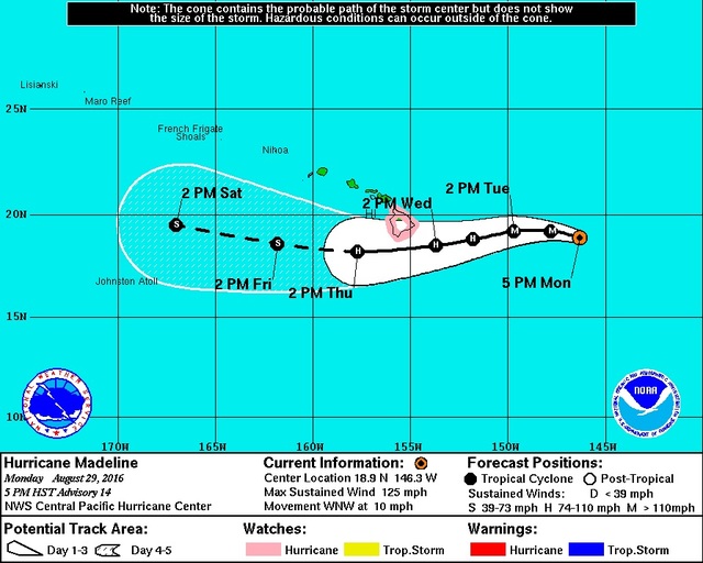
“Potential impacts with high surf and heavy rain could start as early as (today) with high surf and rainfall beginning on Wednesday,” Eric Lau, a forecaster in the weather service’s Honolulu bureau, said Monday afternoon. “The cone of uncertainty lies within the Big Island; that’s why there’s a hurricane watch up in effect.”
At 5 p.m. Monday, Madeline was a category 3 hurricane with maximum sustained winds of 125 mph. The storm was about 575 miles east of Hilo moving west-northwest at 10 mph.
A hurricane watch was issued at 11 a.m. Monday by the NWS, which means hurricane conditions are possible in the next 48 hours. The weather service also issued a flash flood watch for the island for Wednesday and Thursday.
By Thursday, the cyclone is expected to weaken to a category 1 hurricane with maximum sustained winds of 80 mph. Madeline is forecast to pass south of the island Wednesday and Thursday, but landfall remains a possibility.
“Storms like this don’t really like mountainous terrain and once terrain starts interacting with the storm, the tendency is for the storm to weaken,” Lau said.
Ed Teixeira, the county’s Interim Civil Defense Administrator, said his agency was in meetings Monday with state Civil Defense getting ready for a worst-case scenario.
“This is no joke. It is a hurricane watch,” Teixeira said late Monday afternoon. “You know, we were hoping for a much better situation. We’ve still got a day, maybe a day and a half to start preparing ourselves across the island. And that’s where our focus is — preparing, preparing, preparing.
“We’re going to be making some house-to-house notifications beginning (this) morning with our volunteers, especially in the lower Puna area. And the high-surf estimates are going to be pretty high, about 20 feet for east-facing shores. We’ve been in touch with the Waipio Valley community already because they’re very flood prone.”
Teixeira said he’ll meet with community partners and go over matters such as the possible opening of evacuation shelters, if and when schools will be closed, and other closures that might become necessary as the storm approaches.
Teixeira reminded citizens to “be looking at their storm readiness, their families, their properties.”
“If you’re in a flood-prone area, do what you need to do to make your home flood-proof. If you need sandbags, the county is prepared to assist you with that,” he said. “If we’re unlucky and it hits us as a category 1 (hurricane) or a strong tropical storm, we may be unlucky and see the affect of flying debris. So, we need to be thinking about trees and thinking about your furniture on patios and what kinds of steps that we can do for ourselves.”
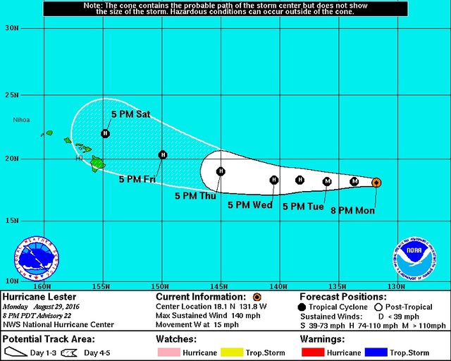
A second storm, Hurricane Lester, also still poses a potential threat to the Islands. At 5 p.m. Monday, Lester was 1,525 miles east of Hilo with category 4 maximum sustained winds of 140 mph. The storm was moving west at 15 mph.
“Sometime around the Labor Day weekend, we could start seeing the impacts of Lester. It is taking a more northerly track as compared to Madeline, but being that far out, it’s still too early to make an educated guess at that,” Lau said.
Lester is forecast to pass the Big Island on Saturday to the north, though a direct hit remains possible. It’s also expected to weaken to a category 1 hurricane as it nears the island, with maximum sustained winds of 80 mph.
“The main focus right now is making sure the residents of Hawaii County are prepared and have their supplies on hand, medication for their families, pets and everything else,” Lau said. “We just want everyone to stay vigilant, be aware of their surroundings, and be prepared to evacuate if necessary.”
Email John Burnett at jburnett@hawaiitribune-herald.com.


